
- MOE
- National Parks of Japan
- Ashizuri-Uwakai National Park
- Characteristics
main body
Characteristics
Great Nature Nurtured by the Japan Current
The dynamic and elegant coastline, the forests, and waters where life shines bright.
The dynamic and elegant coastline, the forests, and waters where life shines bright.
Date of Designation: November 10, 1972
Area: 11,345 ha (land area)
Related Prefectures: Ehime, Kochi
Area: 11,345 ha (land area)
Related Prefectures: Ehime, Kochi
Ashizuri-Uwakai National Park was initially designated a quasi-national park in 1955, and the area was extended to include the Uwakai area and marine park zone and became Ashizuri-Uwakai National Park in 1972. The park is characterized by its coastal strip dotted with islands in southwest Shikoku and the inland landscapes with variations consisting of mountains as high as 1,000 m.
The Ashizuri area is marked by continuous precipitous cliffs developed from coastal terraces and the communities of subtropical marine life and coral reefs nurtured by the Japan Current. In contrast, the Uwakai area appeals to visitors with its subtle inlets unique to a submerged coast and island seascapes, offering beautiful underwater landscapes created mainly of soft corals. The inland area is inhabited by a natural forest of giant trees including Sciadopitys verticillata, Cryptomeria japonica, and Japanese cypress, and the visitors can observe the vertical distribution of vegetation ranging from the warm-temperate zone to the cold-temperate zone. Nametoko Gorge in the upper stream of Shimanto River showcases a magnificent scenery created by a smooth riverbed of granite and a chain of waterfalls as represented by the Yukiwano-taki Falls, along with riparian trees of Quercus salicina and Machilus thunbergii, which attract a host of tourists.
The Ashizuri area is marked by continuous precipitous cliffs developed from coastal terraces and the communities of subtropical marine life and coral reefs nurtured by the Japan Current. In contrast, the Uwakai area appeals to visitors with its subtle inlets unique to a submerged coast and island seascapes, offering beautiful underwater landscapes created mainly of soft corals. The inland area is inhabited by a natural forest of giant trees including Sciadopitys verticillata, Cryptomeria japonica, and Japanese cypress, and the visitors can observe the vertical distribution of vegetation ranging from the warm-temperate zone to the cold-temperate zone. Nametoko Gorge in the upper stream of Shimanto River showcases a magnificent scenery created by a smooth riverbed of granite and a chain of waterfalls as represented by the Yukiwano-taki Falls, along with riparian trees of Quercus salicina and Machilus thunbergii, which attract a host of tourists.
Terrain/ Scenery
Odo Beach
The seashore landscape of abundant variations is one of the key attractions of Ashizuri-Uwakai National Park.
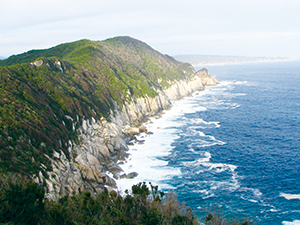
The Ashizuri area in Kochi Prefecture showcases a magnificent view of continuous sheer precipices along the raised beach*1 in the east as represented by Cape Ashizuri and the Tatsukushi Beach. In the west, there is a complicated but subtle landscape dotted with numerous capes and rock reefs as seen in Kanaezaki and the Odo Beach featuring a submerged sawtooth beach*2.
The Ashizuri area in Kochi Prefecture showcases a magnificent view of continuous sheer precipices along the raised beach*1 in the east as represented by Cape Ashizuri and the Tatsukushi Beach. In the west, there is a complicated but subtle landscape dotted with numerous capes and rock reefs as seen in Kanaezaki and the Odo Beach featuring a submerged sawtooth beach*2.
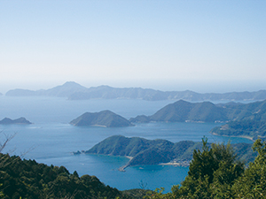
Archipelago of the Uwakai Sea
By contrast, the Uwakai area in Ehime Prefecture forms a typical submerged sawtooth beach, featuring an intricate coastline such as the Miura Peninsula and Yura Peninsula jutting out westward lengthways and a chain of islands in the sea surrounding the coastline to offer magnificent archipelago seascapes abundantly marked with sea cliffs and caves eroded by waves over time.
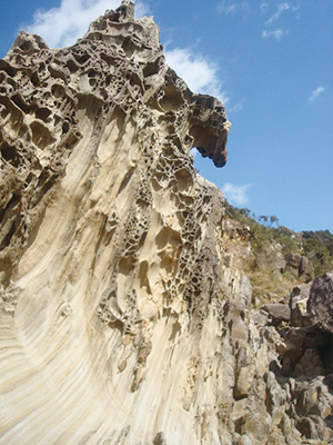
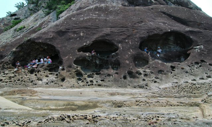
Unusual Rocks on the Tatsukushi Beach and Minokosh
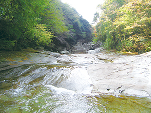
Nametoko Gorge
While the nature of the soil is partially granite as in the Cape Ashizuri, it mainly consists of sandstone and shale belonging from the Mesozoic era and the Tertiary era, forming distinct seashore landscapes affected by wind and wave erosion. Above all, the Tatsukushi Beach is marked by a landscape composed of soft sandstone and unusual rocks. Also, the traces and excretions of extinct plants and animals left in the stratum are considered invaluable in understanding the geology.
*1: Raised beach: A beach resulting from an elevated land or lowered water surface.
*2: Submerged beach: A beach resulting from a submerged land or raised water surface. In contrast, this deeply indented coastline abounds with inlets and bays, presenting a sawtooth-shaped coastline.
*1: Raised beach: A beach resulting from an elevated land or lowered water surface.
*2: Submerged beach: A beach resulting from a submerged land or raised water surface. In contrast, this deeply indented coastline abounds with inlets and bays, presenting a sawtooth-shaped coastline.
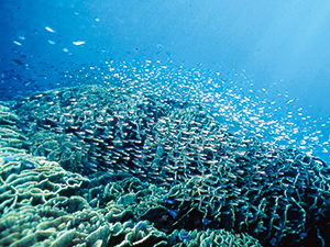
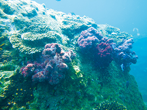
Brightly-colored Underwater Seascapes
Underwater Seascapes
Thanks to the warming influence of the Japan Current, the world's largest warm current, despite of the high latitudes, the waters are populated by the reef-building corals Zooxanthellate scleractinian and subtropical fish Pomacentrus coelestis and Chaetodon auripes living among the corals and present a colorful underwater tapestry of marine life.
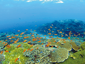
Photo: Shu Nakachi of the Kuroshio Biological Institute (Public Interest Incorporated Foundation)
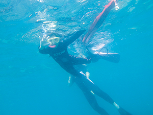
Snorkeling
Soft Coral
Above all, this sea area is considered invaluable because of the abundance of coral species and because it is the northern limit of the worldwide distribution, making it a site to see greatly developed coral communities in terms of its size and species within the temperate waters, even though it does not form a coral reef as seen off the Ryukyu Islands.
In order to preserve this splendid underwater scene, there are six marine park zones including Okinoshima Island, Kashinishi, Tsutomezaki and Shirigai, which are added to the Japan's first marine park zone in the Tatsukushi Beach and Uwakai Sea.
Also, some of the beaches off the Uwakai Sea are designated a Natural Monument of Ehime Prefecture, namely the Uwakai Special Underwater Resources, including the coastal animals (Coelenterata and Echinodermata, etc.), shellfish, and seaweed.
Such an underwater world can be easily viewed by snorkeling, glass-bottom boat, and underwater observatory.
Plants
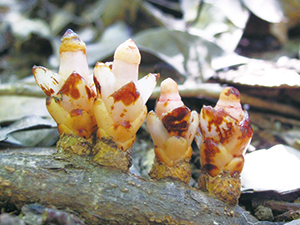
Under the climate of high temperature and heavy rainfall influenced by the Japan Current, the vegetation ranges from the warm-temperate zone to the cold-temperate zone. A stretch of the coast has a wide distribution of warm-temperate evergreen forests and is scattered with a pure forest of Quercus phillyraeoides. The forest area is populated by Goodyera and Tripterospermum japonicum, as well as the Mitrastemonaceae parasites in the roots of Castanopsis sieboldii, whose name was derived from a footman of olden times.
Also, the periphery of Cape Ashizuri is populated by the subtropical plants Livistona chinensis, Alocasia odora, Marattiaceae, and Ficus superba (Miq.) Miq. var. japonica Miq., as well as Camellia japonica, which are the symbol of Cape Ashizuri, bearing an abundance of red flowers.
Mitrastemonaceae
The shore is adorned with Cirsium maritimum makino, green leopard plants, and Chrysanthemum japonense plants, while the communities of succulent Orostachys japonica grow on the cliffs.
In the inland area, there is a riparian forest of Quercus salicina and a mixed forest of Machilus thunbergii, Fagus crenata Blume, Abies firma, and Acer trees in Nametoko Gorge, as well as Sciadopitys verticillata, giant trees of Picea torano and the communities of Rhododendron pentaphyllum var. shikokianum at the summit of Mt. Sasayama.
In the inland area, there is a riparian forest of Quercus salicina and a mixed forest of Machilus thunbergii, Fagus crenata Blume, Abies firma, and Acer trees in Nametoko Gorge, as well as Sciadopitys verticillata, giant trees of Picea torano and the communities of Rhododendron pentaphyllum var. shikokianum at the summit of Mt. Sasayama.
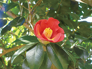
Camellia japonica
Wildlife
The park abounds in numerous species of wildlife such as Japanese macaque and Sika Deer. While Birojima Island off the coast of Kashiwajima Island is the breeding grounds for Calonectris leucomelas, visitors can observe birds such as the Japanese murrelet , Japanese cormorant and grey-faced buzzard.
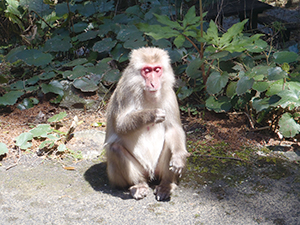
Japanese macaque
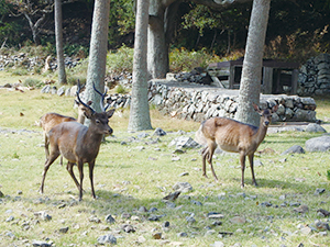
Sika Deer
Culture
Shikoku-no-Michi and Shikoku Pilgrimage
The Shikoku-no-Michi (Shikoku walking trail) is a long-distance nature trail built to introduce the local history about the Shikoku Pilgrimage and the immediate natural environment. Sites along the trail include Kongofukuji Temple, one of the 88 temples of the pilgrimage that was said to be established by Kobo Daishi; Gassan-jinja Shrine and Sasayama-jinja Shrine known as Bangai Fudasho (an additional temple); and many other sites to experience the culture of the Settai Offering along the Shikoku Pilgrimage.

Gift of the Japan Current and Fishery Culture
Thanks to the gift of the Japan Current, this area traditionally abounds with fishery harbors and villages flourished with pelagic fishing. The Kashima-jinja Shrine Grand Festival on Cape Ashizuri illustrate the customs of praying for safety and the rich fish haul as deeply rooted in each area. In addition, the bay facing the inland is rich with red sea bream and Mimachlamys nobilis cultivated in rafts and nets as proof of life blessed with nature since early times.
Page top
Page top
 Chugoku-Shikoku Regional Environment Office
Ministry of the Environment Government of Japan (JCN1000012110001)
11F, Okayama Joint Government Building No. 2, Shimoishii 1-4-1, Kita Ward, Okayama City, Okayama Prefecture 700-0907, Japan
Tel: 086-223-1577 Fax: 086-224-2081 E-mail: REO-CHUSHIKOKU@env.go.jp Location
Copyright Ministry of the Environment Government of Japan. All rights reserved.