
- MOE
- National Parks of Japan
- San'inkaigan National Park
- Characteristics
main body
Characteristics
A Museum of Coastal Landforms
Date of Designation: July 15, 1963
Area: 8,783 ha (land area)
Related Prefecture: Kyoto, Hyogo, Tottori
Area: 8,783 ha (land area)
Related Prefecture: Kyoto, Hyogo, Tottori
The San'inkaigan National Park comprises approx. 75 km of coastline stretching from Kyotango City, Kyoto Prefecture, in the west to Tottori City, Tottori Prefecture. The coastline is a ria coast (submergent coast) where the mountains connect to the ocean; it is characterized by its richly varying coastal landscape comprising landforms of sea cliffs, sea caves, and reefs that have developed significantly and merge with the ocean area. Another characteristic is the expansive sand dune landscape, represented by the Tottori Sand Dunes, that have been formed through wave erosion and by sand carried from river mouths. In this way, unique landforms can be seen throughout the national park, and because these landforms comprise various types of rocks, the park is also referred to as the "Geological Park" or "Beautiful Rock Park."
With the San'inkaigan National Park at its center, the San'inkaigan Geopark was admitted into the Global Geoparks Network in 2010, recognizing the global importance also of the San'inkaigan Coastline.
With the San'inkaigan National Park at its center, the San'inkaigan Geopark was admitted into the Global Geoparks Network in 2010, recognizing the global importance also of the San'inkaigan Coastline.
Terrain/ Scenery
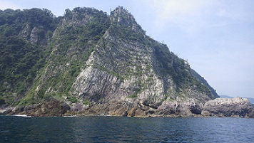
The coastline composing the distinctive landscape of the San'inkaigan National Park is mainly a rocky coastline. Sea cliffs, sea caves, reefs, and other landforms have developed to a striking degree due to erosion and weathering by the rough waves of the Sea of Japan and seasonal winds, while the coast is a complexly intricate ria coast (submergent coast). Moreover, because the coastline's diverse geological structure contains a richly variety of rocks, there are unique landforms dotted throughout the park. Presenting a completely contrasting landscape to that of the rocky coastline areas, the sandy coastline areas have been formed by sand carried from river mouths or produced through wave erosion. In the representative Tottori Sand Dunes, a distinctive landscape has been created due to the movement of sand.
With regard to geology, the main rocks found in the park are volcanic rocks of basalt, andesite, rhyolite (landforms with many joints can be seen throughout the park), and pyroclastic rock and sedimentary rocks of conglomerate, sandstone, and mudstone. Granite can also be seen in some areas. The stratification, non-conformity, jointed dikes, and other diverse occurrences and geological structures that created these rocks are another highlight of the San'inkaigan National Park.
With regard to geology, the main rocks found in the park are volcanic rocks of basalt, andesite, rhyolite (landforms with many joints can be seen throughout the park), and pyroclastic rock and sedimentary rocks of conglomerate, sandstone, and mudstone. Granite can also be seen in some areas. The stratification, non-conformity, jointed dikes, and other diverse occurrences and geological structures that created these rocks are another highlight of the San'inkaigan National Park.
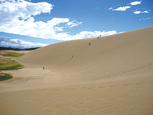
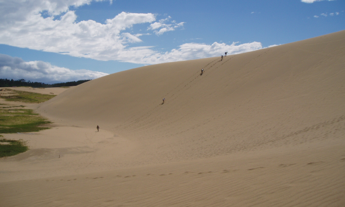
Tottori Sand Dunes
Measuring 16 km east-west and 2.4 km north-south the Tottori Sand Dunes are Japan's largest sand dunes.The dunes were formed by sand flowing down from the Chugoku Mountains, carried by rivers and ocean winds, which then shaped the sand into dunes. Here beautiful patterns created by the sand and wind (wind ripples) and bowl-shaped depressions can be seen, and this unique, richly varying and undulating topography is one of the attractions of the Tottori Sand Dunes.
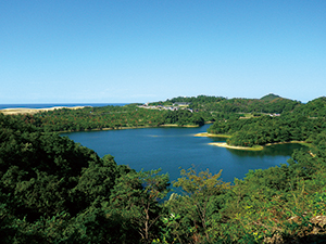
Tanegaike Pond
Located on the southern side of the Tottori Sand Dunes, the natural pond has a circumference of approx. 3.4 km and a surface area of approx. 0.23 km2. The pond's surface is approx. 16 m higher than the surface of the ocean, and its maximum depth is approx. 17 m. The pond is famous for the O-tane Legend about a beautiful woman named Otane, who took the form of a white snake, the spirit of the pond.
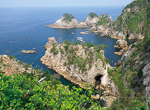
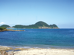
Uradome Beach
A rocky shoreline measuring 15 km in length, the Uradome Beach is surrounded by precipitous cliffs, large and small pine-covered islands and promontories. It is renowned as the Uradome Hakkei (Eight Views of Uradome) for its landscape of white sand and green pine.
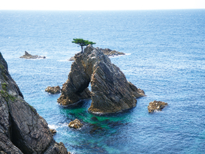
Sengan Matsu-shima Island
This small granite island can be found floating in the ocean immediately north of Ajiro Port. During the Kanbun Era (approx. 300 years ago), there was a magnificent pine tree growing at the top of the rock, and legend has it that Ikeda Tsunakiyo, the Second Lord of the Tottori Domain, decreed that "Whosoever moves this pine with the rock attached to my garden shall receive 1,000 kan ("sen-gan") of silver", and this is how the island is said to have gotten its name.
Yoroinosode
Located in the western part of the Kasumi Beach, these huge cliffs are 65 m high, 200 m long, and have an inclination of 70°; they have also been designated as a National Natural Monument. The cliffs gained their Japanese name (meaning "sleeves of armor") because the alternating columnar and tabular joints look like just that--sleeves of armor.
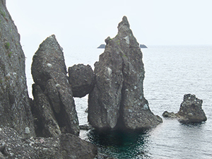
Hasakari-iwa Rocks
Located on the shoreline of the Takeno Beach in an area of wave-cut cliffs, this landform is a rock gate formed along conglomerate strata. The rock forming the roof of a sea cave is thought to have fallen and stuck between the cave walls. The site is designated by Hyogo Prefecture as a Place of Scenic Beauty.
Nekozaki Peninsula
Located at the northernmost point of Hyogo Prefecture, the peninsula looks like a crouching cat when viewed from the ocean. Originally an island, sand and gravel carried by rivers built up and connected the island and mainland, and so on the eastern side of the peninsula is a sandy beach (Takeno Beach). Benches carved by the rough waves of the Sea of Japan can be seen on the western side of the peninsula, and pot holes carved by waves and gravel can also be viewed here.
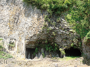
Genbudo Cave
Designated as a National Natural Monument, this cave was formed by volcanic activity 1.6 million years ago. It is possible to view the cave's beautiful columnar and tabular joints. The Japanese name for basalt, genbugan, derives from the name of this cave.
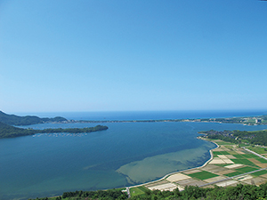
Kumi-hama Bay
This bay was formed when a sandbar was created due to sea levels rising at the end of the last ice age approx. 20,000 years ago, isolating the bay from the Sea of Japan. Today the lagoon measures approx. 28 km in length and connects with the Sea of Japan through the harbor district's Omukai Waterway (approx. 50 m wide).
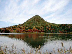
Mt. Kabuto
On the southeast side of Kumi-hama Bay lies Mt. Kabuto, a cone-shaped peak with an altitude of 191 m. Comprising rhyolite lava, a gemstone called chalcedony is extracted from the surrounding area. There is a Kumano-jinja Shrine at the summit which is revered as an object of worship.
Plants
The park has many secondary broad-leafed deciduous forests with only a very small area of primeval evergreen broad-leafed forest on islands, capes, and the grounds of shrines or temples. In sand dune areas, including the Tottori Sand Dunes and Tango Sand Hills, beach plants such as Carex kobomugi, Ixeris repens, Vitex rotundifolia, and Glehnia littoralis can be seen.
The extremely rare Pseudolysimachion ornatum can also be seen in the Tango Sand Hills.
The extremely rare Pseudolysimachion ornatum can also be seen in the Tango Sand Hills.
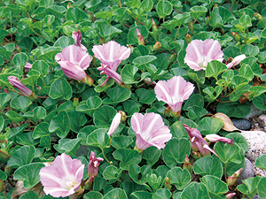
Calystegia soldanella
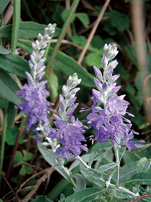
Pseudolysimachion ornatum
Wildlife
Beginning with large mammal species such as Japanese deer and wild boars, the park is also home to many medium-sized mammals, such as foxes, raccoon dogs, and Japanese hares. Also, the Nekozaki Peninsula for is an important stopping point for migrating birds, and during the migration season, large numbers of birds can be seen. In addition, the Maruyama River Basin has become a wildlife reintroduction site for oriental white storks, which at one point were almost extinct.
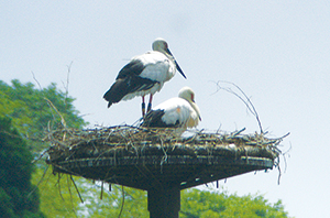
Oriental White Storks
Due to the influence of the Tsushima Current, a relatively large number of southern fish species and small animals can be seen in coastal waters. Numerous mollusks, such as sea slugs and sea hares, also live in these waters. With the high degree of transparency of ocean waters in the San'inkaigan National Park, one attraction is the beauty of the seaweed beds, and a breathtaking underwater landscape can be enjoyed.
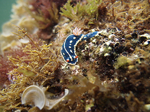
Hypselodoris festiva
Cultural Landscape
Fishing Village
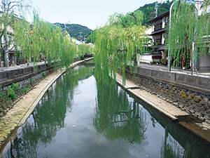
Kinosaki Onsen
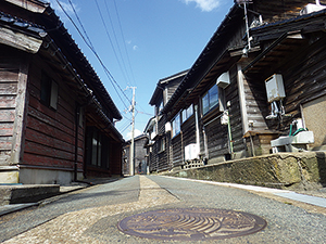
In land areas, fishing villages of tile-roofed houses and the steep escarpments rising behind them create a landscape unique to the Japan Sea coastline that can be seen in the inner parts of bays all along the coast.
Also, at Kinosaki Hot Springs, which are famous for having been visited by Naoya Shiga and numerous other literary legends, visitors can enjoy richly sentimental townscape with gently swaying willow trees.
Also, at Kinosaki Hot Springs, which are famous for having been visited by Naoya Shiga and numerous other literary legends, visitors can enjoy richly sentimental townscape with gently swaying willow trees.
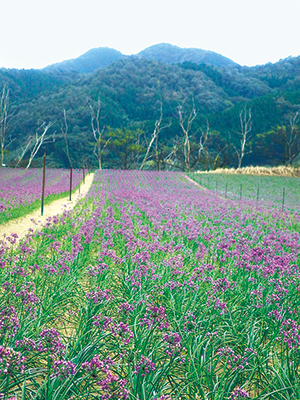
Field of Japanese Shallots
The fields of Japanese shallots that can be seen near the Tottori Sand Dunes also present a landscape unique to the national park.
Page top
Page top
 Kinki Regional Environment Office
Ministry of the Environment Government of Japan (JCN1000012110001)
4F, Sakuranomiya Joint Government Building, Tenmabashi 1-8-75, Kita Ward ,Osaka City , Osaka Prefecture 530-0042, Japan
Tel: 06-6881-6500 Fax: 06-6881-7700 E-mail: REO-KINKI@env.go.jp Location
Copyright Ministry of the Environment Government of Japan. All rights reserved.