
- MOE
- National Parks of Japan
- Rishiri-Rebun-Sarobetsu National Park
- Characteristics
main body
Characteristics
The Northernmost Park Blessed with Myriad Landscapes
Formed by Mt. Rishiri and Ablaze with Alpine Flowers.
Formed by Mt. Rishiri and Ablaze with Alpine Flowers.
Date of Designation: September 20, 1974
Area : 24,512 ha
Related Prefecture: Hokkaido
Area : 24,512 ha
Related Prefecture: Hokkaido
An island of northern extremes and wilderness,as well as splendid flower gardens and the vast ocean.
Rishiri-Rebun-Sarobetsu National Park is the northernmost national park in Japan, boasting a landscape with a variety of mountains, fields of flowers, sea cliffs, wetlands, and coastal sand dunes.
Affectionately referred to as Mt. Rishiri-Fuji, Mt. Rishiri is a beautiful cone-shaped mountain symbolic of the park. Visitors to Rebun-to Island can behold fields of alpine flora and bushes in the lowlands, including valuable alpine plants such as C. marcanthum Sw.var. rebunense. The Bakkai and Wakasakanai Shores present unique landscapes formed by rows of belt-like sand dunes dotted with lakes and reservoirs among sand dune forests of Quercus crispula Blume (oak) and Abies sachalinensis (fir) trees. On the Sarobetsu Plain, there is one of Japan's largest high moors over the peat lands, making it an important stopping point of the migration for wild birds such as wild goose and ducks.
Terrain/ Scenery
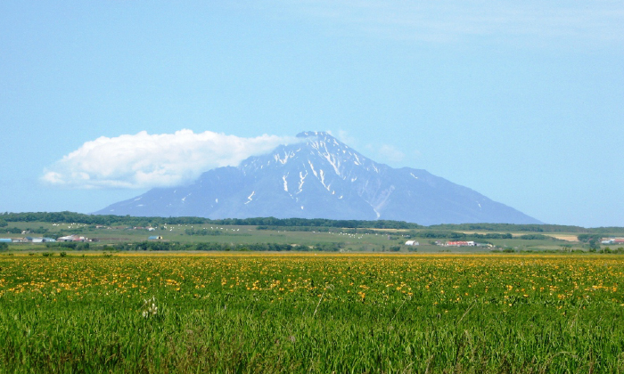
Mt. Rishiri
Mt. Rishiri
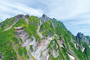
Situated about 20 km from the coast of northwestern Hokkaido, Rishiri-to Island is a cone-shaped volcanic island with a circumference of about 60 km consisting of Mt. Rishiri at 1,721 m above sea level. The appearance of the mountain soaring from the coast makes for the symbolic image of Rishiri-Rebun-Sarobetsu National Park and the heart of its magnificent scenery. Although the hillsides of the mountain have suffered from erosion, creating deep valleys and sharp chines, the foot of the mountain is dotted with lakes, reservoirs, and wetlands, as well as a number of springs.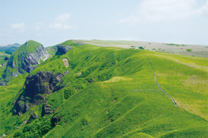
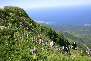
Windswept Grassland on the Rebun-to
Island
Rebun-to Island
Rebun-to Island is an island with a long and elongated shape located roughly 8 km northwest of Rishiri-to Island. It measures about 20 km from north to south and 5 km from east to west. The western part of the island is made up of sea cliffs (a mixture of cliffs and stone formations). The area stretching from west to east consists of gently undulating hills and includes windswept grasslands formed through the impact of strong (predominantly) western winds and cold climatic conditions, with alpine vegetation appearing from sea level. The island is sometimes referred to as a "floating island of flowers" because of its colorful summertime flowers, many of which are endemic to the island.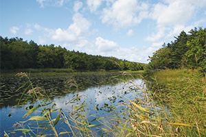
A Colony of Lakes and Reservoirs of a Coastal Sand-dune Forest.
The Coastal Sand-dune Area
The coastal dune areas are populated with elongated strips of dune forests stretching out over 40 km along the coastline and consisting of Mongolian Oaks and Sakhalin fir. The dune forests are also home to some 170 small and larger lake groups. Because the area contains unique landscapes that are unrivaled in Japan, it has been designated as a Hokkaido Designated Natural Monument.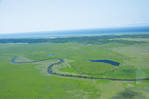
Sarobetsu Plain [Pictures provided by NPO
Sarobetsu Eco Network]
The Sarobetsu Plain
The Sarobetsu Plain is a vast peat land formed in the Sarobetsu River basin. After 6,000 years, the plant residuals accumulate on a peat bed to form moorland vegetation. Along with Kushiro Marsh and Ozegahara, the Sarobetsu Plain is a representative wetland of Japan and boasts the largest size for a high moor on lower lands. Additionally, the visitors can also encounter Hitomi Swamp; home of the largest floating island in Japan, and the development of a large-scale marshland ditch to exhibit the landscapes of wetlands with unparalleled size in Japan.Plants
Due to its geographical characteristics of being an independent peak, Mt. Rishiri makes for a great observatory of vegetation changes by elevation. As you climb up a short distance from the coast, you will be surrounded by mixed needle leaf and broadleaf forests consisting mainly of Abies sachalinensis (fir) trees, a forest of Betula ermanii and Alnus crispa at a height of over 500 m above sea level, as well as the creeping pine zone and fields of alpine floras at 1,100 m and more above sea level.
Thanks to the geographical characteristics of cold climate conditions and being an independent peak, both Rishiri-to and Rebun-to Islands are home to numerous indigenous plants that evolved uniquely.
The area around the summit of Mt. Rishiri bears not only the endemic Papaver fauriei but also Trollius pulcher and Gentiana jamesii that only grow on Mt. Rishiri in Japan.
The Area around the Summit of Mt. Rishiri
Famous as a floral island, Rebun-to Island boasts a host of indigenous plants and alpine plants such as C. marcanthum Sw. var. rebunense, Primula farinosa subsp. modesta var. matsumurae, and Leontopodium discolor.
On the Sarobetsu Plain, when the summer comes, vast wetlands begin to bear an abundance of marsh plants, including Ezokanzou, mountain cranberry and sundew, attracting many visitors.
On the Sarobetsu Plain, when the summer comes, vast wetlands begin to bear an abundance of marsh plants, including Ezokanzou, mountain cranberry and sundew, attracting many visitors.
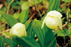
C. marcanthum Sw. var. rebunense
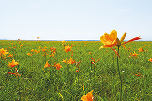
Ezokanzou
Wildlife
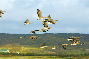
The Sarobetsu Plain is an important stopover point for migrating birds in the spring and fall of each year, including waterbirds such as bean geese. For this reason, it was included in the Ramsar List of Wetlands of International Importance in 2005, and elected as an important bird area by Bird Life International, an international NGO dedicated to the protection of wild birds and their habitats.
Besides Sorex minutissimus hawker, which is one of the world's smallest mammals, the Sarobetsu Plain and a stretch of sand dune forests along the coast are home to Zootoca vivipara, a reptile that can only be found in northern Hokkaido in Japan. It is also home to valuable breeding ground for Emberiza aureola and in recent years, nest building by Japanese cranes has been confirmed.
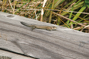
Zootoca vivipara
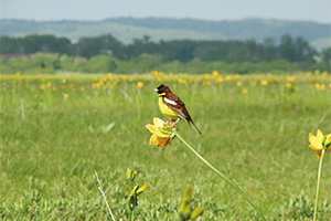
Emberiza aureola
Also on Rishiri-to and Rebun-to Islands, the habitats of rare white-tailed eagles, black woodpeckers and Motacilla flava have been confirmed. As with the Sarobetsu Plain, these islands are an important stopping point for the migration of whistling swans.
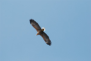
White-tailed Eagles
Culture
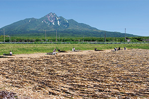
Kelp airing on Rishiri-to Island
The sea areas around Rishiri-to and Rebun-to Islands are known as a chief production center for Rishiri Kombu well-known as high-grade kelp, and the kelp airing makes for a Japanese summer tradition. The area is also a famous site for sea urchin gathering, which is a major marine resource of the islands.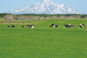
Dairy Farms in the Sarobetsu Plain
On the other hand, the inland area close to the main island is one of the foremost large-scale milk sheds in Hokkaido, and the milk and butter produced in this area are shipped to Hokkaido and many parts of the nation.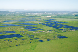
Post Peat Mining Site
Additionally, the Sarobetsu Wetlands was a mining site for peat until 2002, and the peat mined here was processed as fuel and shipped to various places in Japan. At present, the efforts of nature restoration have been taken to restore the vegetation of the mining site.
Page top
Page top
 Hokkaido Regional Environment Office
Ministry of the Environment Government of Japan (JCN1000012110001)
3F, Sapporo Joint Government Building No.1, North 8 West 2 Kita Ward, Sapporo City, Hokkaido Prefecture 060-0808, Japan
Tel: 011-299-1950 Fax: 011-736-1234 E-mail: REO-HOKKAIDO@env.go.jp Location
Copyright Ministry of the Environment Government of Japan. All rights reserved.