
- MOE
- National Parks of Japan
- Chichibu-Tama-Kai National Park
- Characteristics
main body
Characteristics
Situated Proximate to the Metropolitan Area, a Mountainous Park
Brimful of Alluring Forests and Valleys.
Brimful of Alluring Forests and Valleys.
Date of Designation: July 10, 1950
Area: 126,259 ha
Related Prefecture: Saitama, Tokyo, Yamanashi, Nagano
Area: 126,259 ha
Related Prefecture: Saitama, Tokyo, Yamanashi, Nagano
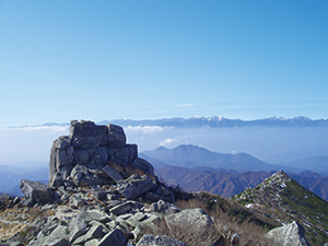
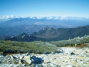
With Mt. Kita-okusenjo as the highest peak (2,601 m above sea level), Chichibu-Tama-Kai National Park is a unique park blessed with mountains and clear streams. The park consists of the lofty Okuchichibu Mountains at 2,000 m extending from Mt. Kimpu and Mt. Kobushigatake to Mt. Kumotori, and the surrounding Mt. Daibosatsu, Mt. Ryokami, Mitake-Shosenkyo Gorge, and Okutama. The mountain range stretches about 40 km from north to south and about 70 km from east to west.
The Okuchichibu Mountains are home to the headwaters and divides the rivers of the Kanto region and central Honshu, including the Chikuma (Shinano) River, Fuefuki (Fuji) River, Tama River, and Arakawa River. River channel erosion has V-shaped valleys with varied landscapes of mountains and valleys.
Thanks to the great accessibility of being nearest to the metropolitan area, this national park has been visited by a number of visitors to enjoy the myriad ways to commune with nature such as hiking, mount climbing, camping, fishing, and river trekking.
Terrain/ Scenery
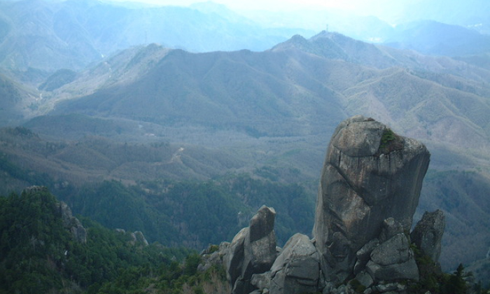
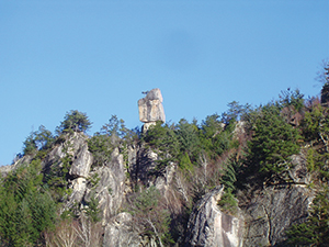
Mt. Kimpu Bristles with Towering Granite Tors
Although Chichibu-Tama-Kai National Park is situated in a mountain region lined with lofty mountains as high as 2,000 m above sea level, there is no volcanic mountain, which is unique for a volcanic nation like Japan. The area is also the site of the headwaters of the Chikuma River, Fuefuki River, Tama River, and Arakawa River. The naturally eroded mountainous region presents deep, beautiful valleys all over the park.
In terms of the geological aspect, Chichibu-Tama-Kai National Park can be broadly divided into east and west. The majority of the Arakawa River and Tama River basins on the east consists of sedimentary rocks and granite distributed around Mt. Kimpu on the west.
The sedimentary rock zone consists of significant amounts of limestone deposits, and there are limestone caves such as Nippara and Yozawa dotted around the area.
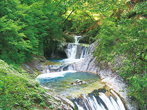
Nishizawa Gorge (Seven-fold ravine enveloped in tender green)
The granite zone is surrounded by the abrupt cliffs of the Nishizawa Gorge and Mitake-Shosenkyo Gorge, which were eroded by rivers, with its varied landscapes of successive falls, folds, and pools.
Granite Rocky Peak near Mawarime Daira
In addition, the areas around Mt. Mizugaki, Mt. Kimpu, and Mawarime Daira consist of towering granite tor formed by erosion and weathering for a dynamic mountain landscape.
Plants
Chichibu-Tama-Kai National Park is located at altitudes between 200 m and 2,600 m above sea level and encompasses a diverse range of vegetation zones depending on elevation. Here visitors can behold a vertical distribution of vegetation as described below.
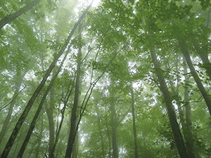
The foot of the mountain is a broad-leaved forest of Japanese beech, Japanese Judas, and maple trees that make for a beautiful site of tender green and crimson foliage.
The foot of the mountain is a broad-leaved forest of Japanese beech, Japanese Judas, and maple trees that make for a beautiful site of tender green and crimson foliage.
The Broadleaf Forest of Ichiri Kannon
The hillside of the main mountain at altitudes between 1,500 m and 2,000 m above sea level is home to a virgin forest of mixed needleleaf and broadleaf primeval forest including Tsuga diversifolia, Picea jezoensis hondoensis, birch, and Japanese Judas trees.
The higher elevations of the Okuchichibu Mountains consist a subalpine coniferous forest covered with Tsuga diversifolia and Veitch's silver fir. The forests from the hillside to the top of the mountain are thickly covered with hepatic and Pterophyta growing on fallen trees on the forest floor and masses of rock that encompass the scenes deep in the mountains, offering unique landscapes with different atmosphere than other mountains similar to the Alps.
The ridgeline beyond 2,500 m is a small habitat of alpine belt vegetation. Near the mountaintop of Mt. Kimpu is a place where colonies of dwarf stone pine and yellow-flowered rhododendron exhibit a unique scenery with a sense of openness that is completely different from the dense and dark coniferous forest.
The Creeping Pine Zone near the Mountaintop of Mt. Kimpu
Chichibu-Tama-Kai National Park exhibits various types of plans unique to mountains and highlands. Owning to a number of mountains consisting of limestone, the vegetation of plants unique to a limestone region is another regional characteristic, making it a habitat for valuable plants that its existence is on the ropes. Many visitors come here to view the seasonal flowers.
Wildlife
The foot of mountains to the vicinity of the mountaintops of the Chichibu-Tama-Kai National Park are covered with thick forests, making it a perfect habitat for animals, such as Asian black bear, Sika deer, and Japanese serow to wild boar, monkey, weasel, Japanese giant flying squirrels and rabbits.
As for birds, the Japanese robin makes its habitat throughout the area and you can find subalpine birds around Mt. Kobushigatake and Mt. Kimpu, such as the spotted nutcracker and the house martin. The park is also a habitat of cicadas, dragonflies, and butterflies. The mountain streams are home to mountain trout and landlocked masu salmon. As a number of clear streams runs through the area, salamanders make their home here, while a beautiful chorus of Kajika frogs can be heard in the area in June and July.
As for birds, the Japanese robin makes its habitat throughout the area and you can find subalpine birds around Mt. Kobushigatake and Mt. Kimpu, such as the spotted nutcracker and the house martin. The park is also a habitat of cicadas, dragonflies, and butterflies. The mountain streams are home to mountain trout and landlocked masu salmon. As a number of clear streams runs through the area, salamanders make their home here, while a beautiful chorus of Kajika frogs can be heard in the area in June and July.
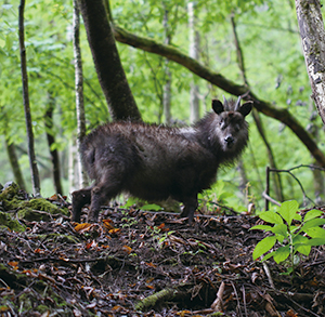
Serows
Culture
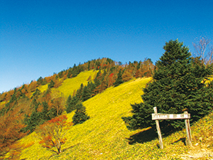
Karisaka Pass
The park has mountain communities developed along its steep-walled valleys and presents unique landscapes coupled with terraced fields and stone steps. The mountain passes connecting mountain communities were used as a lifeline, and a number of historical mountain passes remain in the area, including Karisaka Pass, a pass traditionally used to get to and from Chichibu Road, and Daibosatsu Pass, which became the title of Kaizan Nakazato's novel. These passes are used as hiking courses where visitors can learn the workings of those who live deep in the mountains.
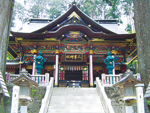
Mitsumine-jinja Shrine
Mt. Mitake and Mt. Mitsumine have traditionally been a mecca of mountain worship, and the mountains formerly flourished as a place to train Buddhist priests. The periphery of Musashi-Mitake-jinja Shrine and Mitsumine-jinja Shrine creates a solemn atmosphere as a site of mountain worship in combination with shrine pavilions, approaches, sacred trees, and temple lodges.
Page top
Page top
 Kanto Regional Environment Office
Ministry of the Environment Government of Japan (JCN1000012110001)
6F Saitama-shintoshin Joint Government Building No.1
1-1 Shintoshin Chuo Ward, Saitama City, Saitama Prefecture 330-9720, Japan
Tel: 048-600-0516 Fax: 048-600-0517 E-mail: REO-KANTO@env.go.jp Location
Copyright Ministry of the Environment Government of Japan. All rights reserved.