
- MOE
- National Parks of Japan
- Oze National Park
- Characteristics
main body
Characteristics
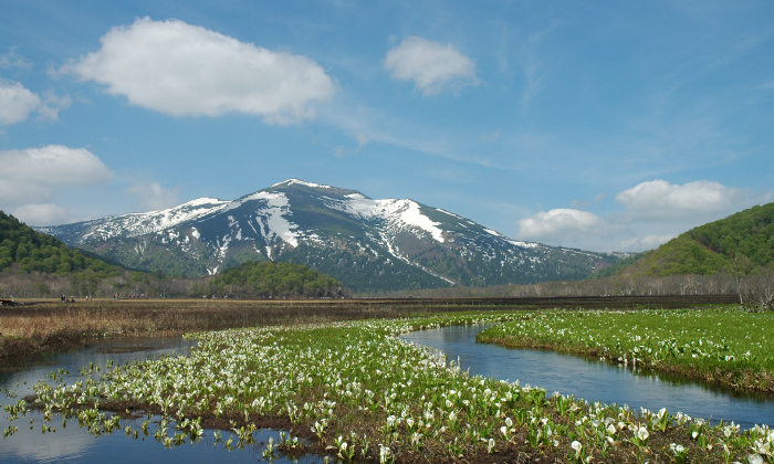
Japan's Most Extensive Mountain Wetlands, Carpeted in Flowers,
Encircled by Famous Peaks
Date of Designation: August 30, 2007
Area: 37,200 ha
Related Prefecture: Fukushima , Tochigi , Gunma , Niigata
Area: 37,200 ha
Related Prefecture: Fukushima , Tochigi , Gunma , Niigata
Oze National Park has a long history. In 1934, it was designated part of Nikko National Park, and then in 2007 the Oze Area was separated from Nikko National Park and combined with surrounding areas such as Mt. Aizu-Komagatake, Mt. Tashiro, and Mt. Taishaku to create Japan's 29th designated national park.
The name "Oze" is widely known due to its mention in Natsu-no Omoide ("Summer Memories"), a nationally beloved song. The region is characterized by its beautiful scenery, ranging from Ozegahara Plateau, the largest high moor on Honshu, and Lake Ozenuma, which was formed by the damming of the headwaters of the Tadami River due to volcanic eruptions, to the surrounding mountains, including Mt. Shibutsu, Mt. Hiuchigatake, Mt. Aizu-Komagatake, Mt. Tashiro, and Mt. Taishaku. Although Oze has faced the threat of development numerous times, its precious nature has been preserved through the cooperation of many people, and the park is also referred to as the "Starting Point for Nature Conservation in Japan."
The name "Oze" is widely known due to its mention in Natsu-no Omoide ("Summer Memories"), a nationally beloved song. The region is characterized by its beautiful scenery, ranging from Ozegahara Plateau, the largest high moor on Honshu, and Lake Ozenuma, which was formed by the damming of the headwaters of the Tadami River due to volcanic eruptions, to the surrounding mountains, including Mt. Shibutsu, Mt. Hiuchigatake, Mt. Aizu-Komagatake, Mt. Tashiro, and Mt. Taishaku. Although Oze has faced the threat of development numerous times, its precious nature has been preserved through the cooperation of many people, and the park is also referred to as the "Starting Point for Nature Conservation in Japan."
Terrain/ Scenery
Mt. Hiuchigatake Viewed from Ozegahara Plateau
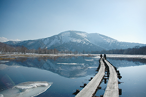
Mt. Shibutsu Reflected in a Lake of Melted Snow (May)
Oze Area
The Oze Area has a basically mountainous region formed through eruptions of the Oze volcanoes. The Lake Ozenuma and Ozegahara Plateau areas are volcanic high moors formed by the damming of a depression by ejecta from volcanic eruptions. Central to these landforms is Ozegahara Plateau, which comprises Honshu's largest (approx. 760 ha) mountain marsh. Also, to the north of Lake Ozenuma and Ozegahara Plateau lie Mt. Keizuru and Mt. Hiuchigatake, the highest peak in northern Japan (2,356 m); to the west lie Mt. Shibutsu, Mt. Koshibutsu, and Mt. Kasagatake; to the south lies Mt. Nikura; and to the east lie Mt. Monomi and Mt. Kinunuma --a series of precipitous ridges that reflect the mountains' golden years.
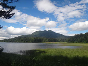
Surrounding Mountains
Surrounding Oze, there is a series of non-volcanic peaks, each with an altitude within the 2,000 m altitude range, including Mt. Aizu-Komagatake to the north and Mt. Taishaku and Mt. Tashiro to the east. Compared with the mountains in the Oze Area, these are relatively gentle-looking mountains, and along their ridgelines can be seen many marshes and ponds.
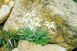
Leontopodium fauriei var. angustifolium
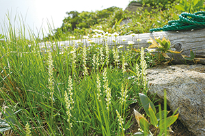
Japonolirion osense
Serpentinite
The mountains surrounding Ozegahara Plateau --Mt. Hiuchigatake, Mt. Keizuru, and Ayamedaira Marsh --are all volcanoes and comprise igneous rock formed by lava, pyroclastic materials, and granite as well as andesite and other solidified magma; however, Mt. Shibutsu to the west comprises serpentinite, a strong basic rock. Because of serpentinite's low mineral nutrient content and the toxicity of heavy metals such as nickel and chromium, it is generally an inappropriate medium for growing plants. For this reason, the plants found on Mt. Shibutsu are plants unique to serpentinite terrain, such as Arenaria katoana, Leontopodium fauriei var. angustifolium, and Japonolirion osense. Also, one reason that the Mt. Shibutsu's forest limit (approx. 1,700 m) is lower than Mt. Hiuchigatake's forest limit (approx. 2,200 m) is thought to be that the serpentinite is not appropriate terrain for trees to grow.
Microtopography of Ozegahara Plateau
Formed approx. 10,000 years ago, Ozegahara Plateau is Honshu's largest high moor. When plants growing in marsh wither and die, they cannot break down completely due to the cold and so accumulate in the water, forming peat and creating a high moor that bulges thickly upwards in the shape of a convex lens. A diversity of marsh plants can be seen on the moor, including Carex middendorffii, Eriophorum vaginatum, and Cranberry, as well as tussocks. On the moor can be seen a microtopography unique to peatlands, forming a mosaic of undulating landforms comprising rises, depressions between the rises, and ponds.
Plants
Vegetation in the Oze Area
In addition to mountain zones with mainly Japanese beech trees growing at altitudes of between approx. 1,000 m and 2,360 m, subalpine belt where trees such as Maries' fir, spruce, and Erman's birch grow, and alpine belt where dwarf stone pine grows, marsh plants, gallery forest, and alpine meadows can also be seen due to the effects of topography and climate.
Vegetation in Surrounding Areas
In the areas around Mt. Aizu-Komagatake in the north of the park as well as around Mt. Kinunuma, Mt. Taishaku, and Mt. Tashiro in the park's eastern and southern parts, forest zones comprising mainly Japanese beech and Maries' Fir can also be seen, and wet grasslands (snow-bed plants) can be observed on mountain summits, forming vegetation with a high degree of commonality overall.
Diverse Plant Species
The Oze Area is located at the meeting point of four zones, each with its own characteristic plants: Northern (mainly relict species from the Ice Age)/Southern (species that migrated from the south during and after the Ice Age); and Pacific Ocean (areas where plants are not especially affected by snow)/Japan Sea (areas where plants are affected by snow). Consequently, the flora is also highly diverse, with more than 10% of higher plants (pteridophyta or higher) confirmed to grow in Japan found in the region (116 families/938 species). Also, with 19 families/42 species of "native plants" (plants first discovered in Oze) and 10 families/19 species of "endemic plants" (plants that only grow in Oze) confirmed, the park is an absolute treasure chest of plants.
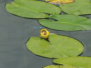
Nuphar pumilum var. Ozeense blooming on a pond (July)
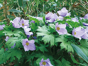
Glaucidium palmatum flowering on the forest floor (June)
Wildlife
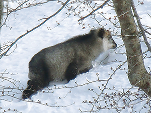
Located at a point where north-south and Pacific Ocean-Japan Sea zones connect, as with its flora, the national park has a diversity of fauna. In particular, many large mammals can be observed here, including the Japanese serow and Asian black bear, which prefer rich forest environments.
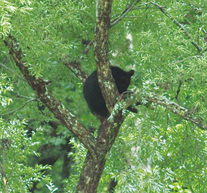
Asian Black Bear
Japanese Serow
Since the park is blessed with not only forest but also waterside environments, there is also a rich variety of birds and insect species; in particular, all 17 of Japan's native northern dragonfly species have been confirmed as living in the park.
Oze's value as a marsh ecosystem has been recognized, and was also registered as a Ramsar Site in November 2005.
Also, in recent years the existence of Japanese Deer --which were said to not live in the region --in the park has been confirmed, and urgent countermeasures are required as the deer are eating and causing other pest damage to precious plant species.
Culture
Ozegahara Plateau, circa 1955
Photograph provided by the Oze Preservation Foundation
History of Nature Conservation
Conservation Beginning with Development Plans
As far back as the Meiji period, there was a scheme to develop electric power sources in Ozegahara Plateau utilizing the abundant water resources of the Tadami River Headwaters (hydroelectric power generation), and following World War II, concrete development plans were announced. In response, the Oze Marsh Conservation Union (predecessor of the present-day Nature Conservation Society of Japan) was formed in 1949 by scholars, cultural figures, and people affiliated with mountain lodges, and through the passionate nature conservation activities of this group and others, the development plan was cancelled, protecting Oze's precious natural environment.
Conservation Beginning with Development Plans
Starting Point for Nature Conservation
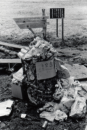
Oze continued to experience new problems even after this -- Destruction of vegetation and littering due to increases in the number of visitors to the area from the early 1960s onwards, as well as plans for road development in the late 1960s and early 1970s. However, dedicated nature conservation activities and other measures such as vegetation restoration, "Take Garbage Home" campaigns, and private car regulations to the park were implemented, protecting Oze's nature. Some of these initiatives were first carried out in Oze, and then subsequently spread nationwide, and so Oze also came to be referred to as the "Starting Point for Nature Conservation In Japan"Oze is also the point where the Kanto Region and the Tohoku Region meet. From the Kamakura period, a road passed through Oze from Katashima Village in Gunma Prefecture to Hinoemata Village in Fukushima Prefecture, placing Oze in the middle of commodities and cultural exchange.
Linking Numata City and Aizu-Wakamatsu City, this road was called the "Aizu-Kaido" on the Gunma side and the "Numata-Kaido" on the Fukushima side. Stretching approx. 180 km from Numata Castle to Tsurugajo Castle via Lake Ozenuma, this was an important road, and checking stations were established at Hinoemata and Tokura in Katashina Village. In addition, during the Boshin War at the end of the Edo Period, the Aizu army camped on the Oe Marsh and clashed with a punitive force at Tokura; the earthworks constructed on the Oe Marsh at that time remain today. Vestiges of the road from that time can be seen in parts of the mountain trail from Nanairi to Ichinose, passing through the Numayama Pass, Oe Marsh, Lake Ozenuma, and Sanpei-shita; the road along the Michigisawa Gorge is especially recommended for viewing the fresh green leaves of spring and crimson-tinged leaves of autumn.
The region has also long nurtured its own unique culture. In particular, the Hinoemata Kabuki which has been passed down over generation in Hinoemata Village is a rural Kabuki theater tradition with a history of over 260 years, and its performance has also been designated as a National Important Tangible Folk-Cultural Property.
Page top
Page top
 Kanto Regional Environment Office
Ministry of the Environment Government of Japan (JCN1000012110001)
6F Saitama-shintoshin Joint Government Building No.1
1-1 Shintoshin Chuo Ward, Saitama City, Saitama Prefecture 330-9720, Japan
Tel: 048-600-0516 Fax: 048-600-0517 E-mail: REO-KANTO@env.go.jp Location
Copyright Ministry of the Environment Government of Japan. All rights reserved.