
- MOE
- National Parks of Japan
- Hidakasanmyaku-Erimo-Tokachi National Park
- Guide of Highlights
ここから本文です。
Highlights of Hidakasanmyaku-Erimo-Tokachi National Park
Nissho Pass [Shimizu Town and Hidaka Town]
![photo of Nissho Pass [Shimizu Town and Hidaka Town]](/park/content/000261948.jpg)
Nissho Pass [Shimizu Town and Hidaka Town]
Nissho Pass (1,106m) on National Route 274 is the watershed between Hidaka and Tokachi. Erman's Birch dominates the surrounding forest, and in the open areas, grassland flowers such as Chishimafuro (Geranium) and Shikotan-Kinpouge (Ranunculus) grow.Saru River Headwaters Primeval Forest
Saru River Headwaters Primeval Forest
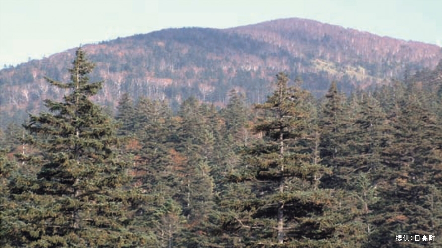
National Route 274, which connects Sapporo to eastern Hokkaido, crosses the northern part of the Hidaka Mountains. From the car’s windows, you can see the beautiful gorge scenery of the headwaters of the Saru River and the primeval coniferous forest, designated as a national natural monument.Mt. Kita Hidaka [Hidaka Town]
![Mt. Kita Hidaka [Hidaka Town]](/park/content/000261949.jpg)
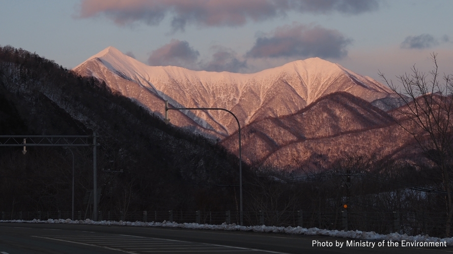
Mt. Kita Hidaka [Hidaka Town]
Mt. Kita Hidaka is home to the park's only ski area, with a wide variety of trails to satisfy both beginner and advanced skiers. In summer, the ski trails are used as a route for climbing Mt. Kita Hidaka.Mt. Poroshiri [Biratori Town and Niikappu Town]
![photo of Mt. Poroshiri [Biratori Town and Niikappu Town]](/park/content/000261950.jpg)
Mt. Poroshiri [Biratori Town and Niikappu Town]
Mt. Poroshiri (2,052 m) means “big mountain” in the Ainu language, features cirque formations on its ridges, and is the only peak in the Hidaka Range exceeding 2,000 meters. It is considered one of the most challenging mountains among Japan’s “Hundred Famous Mountains.”Mt. Petegari [Shin-Hidaka Town and Taiki Town]
![photo of Mt. Petegari [Shin-Hidaka Town and Taiki Town]](/park/content/000261164.jpg)
Mt. Petegari [Shin-Hidaka Town and Taiki Town]
Mt. Petegari (1,736 m), which straddles the border between the towns of Shinhidaka and Taiki, is one of the most famous peaks in the Hidaka Mountains and is called “Harukanaru-mountain” by mountaineers because of its extremely long approach. It is also as renowned as Mt. Poroshiri. It encompasses the ruggedness, profoundness, and beauty of the Hidaka Mountains.Mt. Apoi [Samani Town]
![photo of Mt. Apoi [Samani Town]](/park/content/000261951.jpg)
Mt. Apoi [Samani Town]
Mt. Apoi is renowned throughout Japan for its flowers, with a wide variety of alpine plants appearing from around 350 meters. Despite its modest elevation at 810 m, Mt. Apoi offers a wide range of alpine plants and endemic species, providing excellent views, and is popular among visitors. UNESCO designated the entire town of Samani as a World Geopark.Mt. Tsurugi [Shimizu Town]
![photo of Mt. Tsurugi [Shimizu Town]](/park/content/000261952.jpg)
Mt. Tsurugi [Shimizu Town]
Mt. Tsurugi (1,205 m) is at the end of a branch ridge extending east from Mt. Memuro in north Hidaka. It can be easily viewed from Obihiro City and Shimizu Town and is popular among locals. The summit offers excellent views and is one of the rare day-trip mountains in Hidaka, attracting many climbers.Mt. Tokachi-Poroshiri [Obihiro City]
![photo of Mt. Tokachi-Poroshiri [Obihiro City]](/park/content/000261953.jpg)
Mt. Tokachi-Poroshiri [Obihiro City]
Straddling Obihiro City and Nakasatsunai Village, Mt. Tokachi Poroshiri (1,846 m) is located on a ridge extending east from the main ridge line of the Hidaka Mountains, and is locally known as “Kachiporo.” After climbing the steep slope, hikers reach the summit, which offers a panoramic view of the Tokachi Plain.Tenma Kaido, Notsuka Pass
Tenma Kaido, Notsuka Pass
National Route 236, called “Tenma Kaido,” crosses the southern end of the Hidaka Mountains. The pass has numerous tunnels, but both sides of the pass through deep valleys allows visitors to view southern Hidaka’s mountain scenery from the car windows.Funbe Falls [Hiroo Town]
![photo of Funbe Falls [Hiroo Town]](/park/content/000261954.jpg)
Funbe Falls [Hiroo Town]
Located along Route 336, Funbe Falls features abundant spring water flowing down the rock face from the top of the coastal cliffs. In winter, the water freezes to form magnificent ice columns. Funbe is an Ainu word for whale and is found as a place name throughout Hokkaido.Lake Toyoni [Erimo Town]
![photo of Lake Toyoni [Erimo Town]](/park/content/000261167.jpg)
Lake Toyoni [Erimo Town]
Nicknamed “Heart Lake” because it looks like a heart when seen from above, Lake Toyoni is a natural lake. It is also known locally as “Horseshoe Lake” because it resembles a horse’s hoof.Cape Erimo [Erimo Town]
![photo of Cape Erimo [Erimo Town]](/park/content/000261168.jpg)
Cape Erimo [Erimo Town]
Cape Erimo is a sharply pointed promontory facing the Pacific Ocean, where the Hidaka and Tokachi coastlines collide. The cape is windy all year round. Visitors can see harbor seals on the reefs extending offshore in the spring and summer. A park path around the cape allows visitors to enjoy the coastal scenery.