

Quality of the Environment in Japan 1994
D. Natural Scenery
Excellent natural phenomena, geography and topology, such as waterfalls, valleys, and mountains, are elements characteristic of ecosystems themselves as well as symbols of regions and also treasured for providing places for study, recreation, tourism, and exploration of tlw wonders of nature. Moreover, the emotional boost from viewing such beautiful natural scenery can help people to recover spiritually.
According to the results of the Natural Landscape Resources survey that was part of the Third National Survey on the Natural Environment, Japan has 15,468 sites of natural landscape resources. Of these sites, the most numerous are waterfalls (2,488 sites), followed by gorges and valleys (996 sites), nonvolcanic outstanding peaks (993 sites), lakes and marshes (872 sites), sea-eroded cliffs (734 sites), and sand and gravel beaches (632 sites).
These seven types of natural landscape resources account for about half of all. An examination of the distribution of natural landscape resources shows that the Chubu region, which includes the Japan Alps, leads with 22.2% of the total, followed by the Tohoku region with 21.4%, the Kyushu region with 14.2%, and the Kanto region with 10.5%, in that order. An examination of the distribution of natural landscape resources by type of scenery shows that the Chubu region leads in the most volcanic and mountainous landscape, while the Chugoku region is rich in limestone-bearing landforms. In terms of water-related landscape, the Chubu region is rich in lake and stream landscape, the Tohoku region is rich in lake and marsh landscape, and Kyushu is rich in seashore landscape.
An examination of the preservation of natural scenic resources reveals that about half are under a national park or some other form of preservation system, with national parks accounting for 23.2% of the total and quasi-national parks accounting for 14.6% (Figure 4-5-7).
Fig. 4-5-7 The Preservation of Natural Landscape Resources (total natural scenic resources)
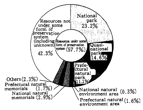
Reference : Environment Agency; Natural Surveys on the Natural Environment, Natural Land scape Resources Survey
An examination of the type of preservation system shows that the number of landscape resources under some form of preservation system outnumbers those that are not (including unknown), which are nonvolcanic single peaks, stalactite grottos, and terraced banks formed by the action of flowing water. In terms of usage patterns, resources that can be designated for special use account for 13.3% of the total; in the case of most of these resources, the number of users per year amounts from around 10,000 to 50,000 people. Nearly two-thirds of the total natural landscape resources are subject to development activities or affected secondarily by such development activities. In terms of type of activity, the most common is access by people (15.8%), followed by agricultural development (10.0%), and tourism development (9.5%), in that order.
The term "the world natural heritage" is based on the definition of "natural heritage" in the Convention for the Protection of the World Cultural and Natural Heritage (1972), according to which natural sites are of outstanding universal value from the point of view of aesthetics, science, or conservation. Sites where excellent natural environments are preserved are to be regarded as the common property of mankind and subjected to thorough conservation measures. It was decided to admit Japanese sites onto the list of world heritage sites for the first time in December 1993. The sites admitted included Yakushima in Kagoshima Prefecture, which boasts very special vegetation from sea level up to an elevation of 1,900 meters, including huge groves of Yaku cedars, as represented by the ancient Jomon cedars, and the Shirakami-sanchi in Aomori and Akita prefectures, where prehistoric beech forests provide habitats for rare species of birds.
As of January 1994, 106 sites (including 16 mixed heritage sites) were registered as natural heritage sites on the list. Seven sites were registered as endangered nature heritage sites. Examples of sites registered as world natural heritage sites include Grand Canyon and Yellowstone National Parks in the United States, the Great Barrier Reef in Australia, and the Galapagos Islands National Park in Ecuador. Endangered nature heritage sites include the Nimba mountain chain in Guinea and Cote d'Ivoire and the Everglades National Park in the United States.
(2) Ecosystems by Region
A. Mountains
Most mountains are covered with forests, which provide animal habitats and places for breeding as well as provide humans with a variety of resources. Figure 4-5-8 shows the relationship between the degree of forest cover and the angle of incline.
Fig. 4-5-8 Distribution of Forests by Degree of Incline
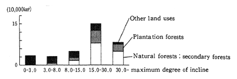
Source : Made by the Environment Agency based on materials from the National Land Agency
From this figure it is clear that the higher the average degree of incline, the greater the proportion of forest cover, and inclines 30 degree and over are mostly covered by forests. Such mountain forests play an important role in preventing damage to the environment, such as soil erosion. Forests planted by man are not uncommon among these mountain forests; their proportion declines, however, as the degree of incline increases. Still, the proportion of planted forests is 13% even on slopes with an incline of 30degree and more, so it is clear that the hand of man has recently been reaching ever farther into the remote mountain country.
Mountains are home to many of Japan's ecosystems that retain their original natural character. According to the Third National Survey on the Natural Environment, mountains account for most of the regions with a high distribution (number of mesh) of beech forests retaining a high degree of naturalness. Areas with a high distribution of laurilignosa tend to be mountainous regions such as the Kii and Kyushu mountains. Moreover, mountains are home to a wide variety of ecosystems.
For example, an examination of the regions where butterfly varieties are particularly abundant clearly indicates that mountainous regions, beginning with the Chichibu region, are home to a wide range of species (Table 4-5-3). Tall mountains withcold, challenging environments are characterized by the survival of special ecosystems consisting of high-mountain plants and butterflies.
Table 4-5-3 Landforms with High Degrees of Naturalness
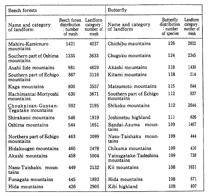
Reference: Comprehensive Report, the Third National Survey on the Natural Environment
Mountainous regions have always played important roles in people's spiritual lives as a focal point of faith and as regional symbols. Moreover, these roles are today joined by equally important roles in providing sites for recreation and tourism. Surveys of natural landscape resources rank the top three as waterfalls, volcanoes, and valleys/ gorges, thus underscoring the important position of mountain regions.
The population of mountainous regions has been declining in recent years, and this decline has led to a deterioration in the usage and management of mountain environments, especially in the management of afforested areas, which require much manpower. As a result, mountain environments and their usage patterns have been undergoing rapid changes.
B. Lakes and Marshes
Japan has a wide variety of lakes and marshes, including lakes and marshes in mountainous regions, flatlands that are the remains of enclosed arms of the sea left behind by retreating seawaters, and lakes in the vicinity of seacoasts. The Lakes and Marshes Survey in the Fourth National Survey on the Natural Environment, which was carried out by the Environment Agency in fiscal 1991, focused on 480 natural lakes and marshes (two of the 480 lakes were found to have disappeared) that were, in principle, 1ha or more in size. The surface area of the lakes and marshes studied was found to total 2,374.37km or 0.63% of Japan' s land surface. The shorelines of 476 of the lakes studied were found to stretch a total of 3,184.2km. Of this total shoreline, 56.6% was categorized as completely natural shoreline (45.0% without cliffs and 11.6% with cliffs), 12.4% as seminatural shoreline, 303% as artificial shoreline, and 0.7% as submerged. A comparison of the results of this survey with those of the second survey indicates that natural shorelines are declining, with a large proportion being replaced by artificial shore1ines.
An examination of the usage patterns of lake shorelines reveals that 56.7% are natural areas (with 36.9% forested and 19.7% in other natural categories), 23.0% are agricultural land, 19.6% are urban, industrial, or other land, and 0.8% is submerged. Nationwide, the proporti n of lake shoreline preserved in the natural state, including submerged areas, is 57%, while the proportion that has been subjected to change including conversion to agricultural, urban, and industrial uses, at the hands of man is 43%.
When areas adjoining lake shorelines become subjected to urbanization or industrialization, the adjoining lake shorelines also come under development in line with the advance of the urbanization or industrialization. When lake shorelines are under this kind of usage they become subjected to man-made changes. At 27 of the lak studied the man-made changes had progressed to the point where 50% or more of the shoreline was artificial and 30% or more of the shoreline had become urban land. Two lakes were added to this total in the fourth survey: Sakata Pond and Kugushi Lake.
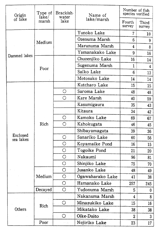
Table 4-5-4 Number of Fish Species Inhabiting Designated Lakes
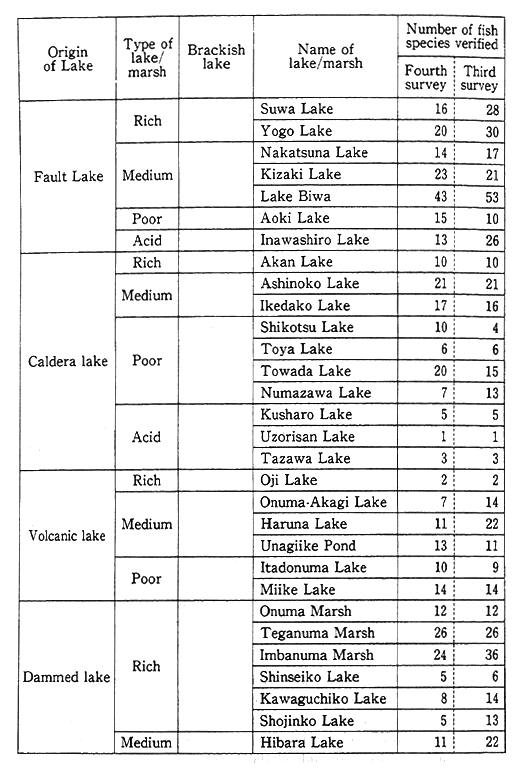
Source : Environment Agency
Over the 46-year period from 1945 to the fourth survey, 66 lakes, with a total surface area of about 347km were reclaimed from the sea or by landfills. Lakes originating on areas reclaimed from the sea or through landfills account for 14.6% of the total surface area of the lakes and marshes covered and analyzed. The overwhelming majority (55 lakes, or 98.5%) of these lakes originating on areas reclaimed from the sea or through landfills were made in the 34 years from 1945 to the second survey (1979), and lakes disappeared completely during that period due to land reclamation projects.
A study of 60 specially designated lakes revealed that each lake provided, on the average, habitats for about 25 species of fish. The lake reported to be the most abundant in fish species was Hamanako Lake, with 257 species, which was well ahead of the runner-up, Nakaumi Lake, with 96 species (Table 4-5-4). The report verified the presence of fish introduced from foreign countries in about one-third of the specially designated lakes, with the major varieties led by rainbow trout (salmon family), found in 21 lakes ; sougyo (carp family), found in 22 lakes; and big mouse (sunfish family), found in 20 lakes. The number of lakes in which fish introduced from foreign countries were present did not show much year-to-year variation. Big mouse and other fish introduced from foreign countries are gradually developing a secure presence in lakes throughout Japan, and it will be necessary to monitor them as one of the elements in the changing profile of fish species in Japan's lakes.
C. Rivers and Streams
The second and third National Surveys on the Natural Environment, carried out by the Environment Agency in 1979 and 1985, respectively, which studied the natural environment of the main flows of Class One rivers and streams throughout Japan, found that of the 11,412.0km of banks of rivers and streams studied, 2,441.5km nationwide abut embankments or other man-made structures during times of normal water flow, accounting for 21.45% of the total length of river beds (Figure 4-5-9).
The greatest increase in the length of man-made river beds is found in Honshu-Pacific (mid and southern portions) water system groups (116.3km) and in Honshu-Japan Sea water system groups (109. 1km). An examination of the relative proportions of that increase shows Kyushu-Japan Sea water system groups leading with a 20.5% increase.
Fig. 4-5-9 Status of Riverbanks Nationwide
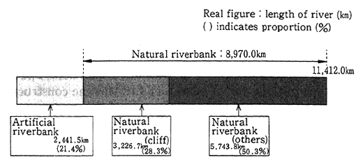
Note : Data are as of 1985. Changes in the riverbanks are indicated by the average distance between the right and left side of the banks. Artificial riverbanks refers to those that during periods of normal flows abut protective embankments or other artificial structures.
Source: Environment Agency, the Third National Survey on the Natural Environment, River Survey, 1985
One of the major objectives of this survey was to ascertain the relationship between man-made river beds and the biological profile. An examination of the usage pattern of the river beds show that Japan has 5,055 river districts nationwide with river beds (refers to the normally dry portion of the bed between the river channel and the riverbank) with a width of 100 meters or more, accounting for 44.3% of all river districts nationwide. By usage pattern, 33.3% of total river districts were natural land, 7.6% were agricultural land, 0.8% were as yet unused land already prepared for construction, and 2.6% was used for construction, indicating a tendency toward increase in agricultural land and land used for construction.
Dams, sluices, and other structures to intercept the flow of rivers may divide the habitats of fish species if the structures do not incorporate appropriate devices to help the fish to move upstream. For this reason, the Environment Agency carried out a survey in 1985 of structures that cross rivers and streams to ascertain the various factors that affect the habitats of fish. The proportion of structures crossing rivers and streams that incorporate fish ladders was 30.6%. About 60% of all structures allow fish to move upstream. However, about 12% of the structures that cross rivers and streams and were fitted with fish ladders were not functioning properly. Thirteen rivers, including the Abashirigawa and Takase Rivers, had either no cross-river structures or functional fish ladders that allowed migratory fish like salmon, sakua trout, and ayu to migrate upriver to the upper reaches of the surveyed districts (Table 4-5-5). From the time of the second survey to that of the third, access to the upper reaches of three rivers (the Shirobetsu, Shimantogawa, and Shirakama Rivers) became impassable. The reason for the blockage of the river to migratory fish was the construction of cross-river structures in the mid and upper reaches.
Table 4-5-5 Rivers that Allow Fish to Migrate Upstream (100% of Districts that Allow Upstream Migration)
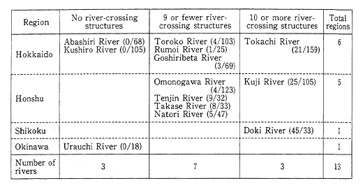
Note : Figures in parentheses indicate numbers of river structures / numbers of districts surveyed
Source: River Survey, the Third National Survey on the Natural Environment, 1985, Environment Agency
Nine rivers have a high proportion of districts that are passable by migratory fish (90% or more of the length of the river is passable). Six rivers have a low proportion of districts that are passable by migratory fish (10% or less of the length of the river is passable).
Rivers that Allow Fish to Migrate Upstream (100% of Districts that Allow Upstream Migration)
Rivers in Japan tend to flood often due to their steep banks and Japan's plentiful precipitation. As a result, river channels and flow conditions are unstable. Moreover, in recent years demand for water has been increasing with the rise in living standards, and dams and other multipurpose river-crossing structures have been built in the upper reaches of rivers for flood control and to allow the water to be used for irrigation. In addition, dams and other structures are being built in the lower reaches of rivers. For example, arguments have been put forward regarding dams at the estuaries of the Nagara River. The effects of such dams on the natural environment may include effects on the upstream migration of fish. It is necessary to undertake thorough surveys on the effects of river-crossing structures on fish and other ecosystems.
Table 4-5-6 Rivers with Numerous Fish Species
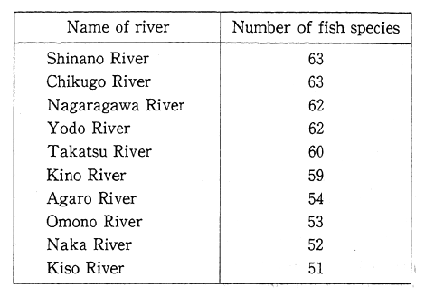
Source : River Survey, the Third National Survey on the Natural Environment, 1985, Environment Agency
Note : The presence of species was listed when verified by on-site inspection or by local hearsay
Table 4-5-6 summarizes fish habitat conditions by river. The rivers with the largest number of varieties of fish are led by the Shinano and Chikugo Rivers, each with 63 species, and most such rivers are main rivers in Honshu. It is noteworthy that rivers and torrential streams in Hokkaido, which is separated from Honshu by the Blakiston Line as far as animal profiles are concerned, are subject to icing and are short and, as such, home to few fish species.
D. Wetlands and Tidal Pools
Within the natural environment, wetlands and tidal pools are home to special ecosystems and play an important role as breeding grounds for aquatic animals and waterfowl.
Under the RAMSAR Convention (Convention on Wetlands of International Importance especially as Waterfowl Habitat), wetlands are treated as a broad concept that embraces lakes and marshes, rivers, swamps, and tidelands. Wetlands, which have more water than ordinary land surfaces, allow the formation of special ecosystems that provide habitat for animals and plants that can live only in such environments. As a result, wetlands are the preferred habitat for aquatic animals and waterfowl.
Four places in Japan were originally registered as wetlands under the RAMSAR Convention: Kushiro-shitsugen in Hokkaido, Izunuma and Uchinuma in Miyagi Prefecture, Kutcharo-ko in Hokkaido, and Utonai-ko in Hokkaido. Five places (Kiritappu-shitsugen in Hokkaido, Akkeshi-ko and Bekambeushi-shitsugen in Hokkaido, Yatsu-higata in Chiba Prefecture, Katano-kamoike in Ishikawa Prefecture, and Biwako in Shiga Prefecture) were added at the Fifth Conference of the Contracting Parties of the RAMSAR Convention, which was held in Kushiro, Japan, on June 10, 1993, bringing the total number of registered Japanese wetlands to nine.
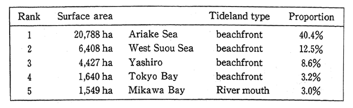
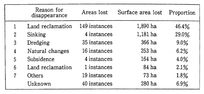
Within the category of marine environments, tidelands function as an important ecosystem that provides habitats for special marine animals and waterfowl. Most tidelands are inland bodies of water that are easily subject to pollution but difficult to clean up. Studies indicate, for example, that natural tidelands have much greater cleaning capabilities than artificial tidelands. According to surveys undertaken by the Environment Agency from fiscal 1989 to 1991, the total surface area of tidelands amounted to 51,462ha. Four tidelands, beginning with the prefecture-established A tideland in Kumamoto Prefecture, were reported to exceed 1,000ha in surface area. A tideland and the other three tidelands account for about 40% of Japan's total tidelands (Table 4-5-7). It was learned that 4,076ha of tidelands have disappeared since 1978. About 46% of these tidelands, which by and large front on inlets, were lost due to their conversion into reclaimed land in the course of development (Table 4-5-8)
Tidelands are protected by the ongoing implementation of a comprehensive set of measures including the Natural Park Law, the Wildlife Protection and Hunting Law, and other provisions for the protection of tidelands based on the Basic Program for the Conservation of the Environment of the Seto Inland Sea, as well as by the Law Concerning Special Measures for Conservation of the Environment of the Seto Inland Sea, which provides for the prevention of damage due to eutrophication, the protection of natural beaches, and for the protection of the environment in regard to land reclamation.
Table 4-5-7 Surface Area of Existing Tidelands by Sea Region
Proportion represents the percentage of existing tidelands nationwide
Source : Environment Agency
Table 4-5-8 Reasons for the Disappearance of Tidelands
(includes multiple reasons)
Note : Proportion represents the percentage of existing tidelands nationwide "Natural changes" refers to erosion of coastlines, drifting of sand, etc.
Source : Environment Agency
E. Shorelines
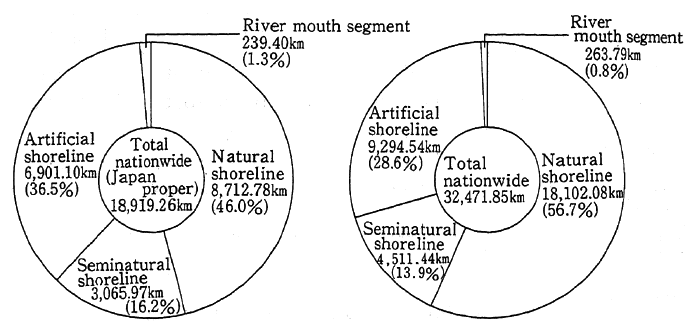
Shorelines that preserve the natural environment not only are important in providing places for animals to live and breed but also have always provided places for recreation, often in well-loved sites of great scenic beauty. Man-made changes to the shoreline proceeded at a fast pace during Japan's period of rapid growth, in step with the progress of urbanization and the development of industry. The total length of Japan's shoreline is 32,472km, of which 58.3%, or 18,919km, is part of Japan's main islands. The part of Japan consisting of minor islands accounts for only 5% of Japan's territory but for 41.7%, or 13,553km, of its shoreline.
Fig. 4-5-10 Proportional Classification of Coastlines
Source : Environment Agency; The Third National Survey on the Natural Environment, Coastline Survey
Note : As of 1984
Applies to shorelines nationwide including minor islands with a radius of 100 meters or more Japan proper refers to Hokkaido, Honshu, Shikoku, and Kyushu
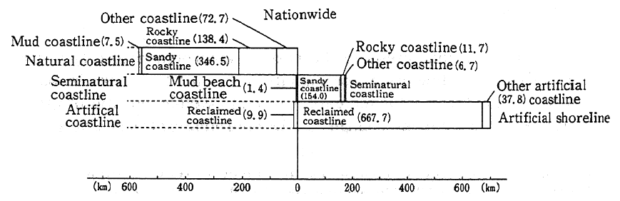
The classification of coastline is as follows Natural coastline: shoreline without any man-made structures.
Seminatural coastline : no man-made structures within the tide line (the strip of shore between high tide and low tide); however, man-made structures may exist in the back shore (that land behind the tide line that still receives the effects of the waves).
Artificial coastline: coastline with man-made structures within the tide line
Fig. 4-5-11 Changes of Coastlines, 1979-1984
Source : Environmest Agency, Coast Line Survey, the Third National Survey on the Natural Environment
This shoreline is not only long but more diverse than that of the main islands. A comparison of the classification of Japan's coastline shows that about half (56.7%) is natural coastline, followed by artificial shoreline (28.6%). Excluding the minor islands, natural shoreline accounts for slightly less than half (46.0%) of Japan proper. In other words, artificial shoreline accounts for more than one-third (Figure 4-5-10).
An examination of the changes taking place to the shoreline from 1978 through 1984 shows that 565km of natural shoreline were lost during that period, a loss of about 3% of the total shoreline (Figure 4-5-11). Most of the natural shoreline lost consisted of sandy shores. It is known that most shore protection projects and development projects were carried out on sandy shores as opposed to coasts consisting of volcanic rocks or undeveloped beaches. Protection of the natural environment of such shorelines is carried out under the Natural Park Law and the Law Concerning Special Measures for Conservation of the Environment of the Seto Inland Sea.
F. Areas on the Periphery of Cities
People often overlook the greenery and domesticated plants and animals that surround them. Such organisms not only constitute an integral part of Japan's natural environment but also are indispensable in familiarizing people with the natural world in the course of their daily lives. The natural environment to be found in the peripheral areas surrounding cities plays an important role in improving the climatic conditions and environment of cities, for example, by ameliorating the phenomenon known as the "heat island" effect. It also has the function of reflecting the condition of the climate, water, and soil within the city itself.
The National Survey on the Natural Environment classifies vegetation according to the degree of human disturbance. An analysis of the natural condition of metropolitan Tokyo and Kanagawa, Saitama, and Chiba Prefectures, Aichi Prefecture, and Osaka-fu, based on a fivefold classification into natural vegetation, secondary vegetation, plantation, agricultural land, and so on shows that there is a large proportion of urban land where greenery is scarce because these urbanized areas are relatively lacking in natural vegetation compared to the national average (Figure 4-5-12). In the outskirts of cities, secondary vegetation provides easy access to nature and habitat for wildlife ; however, such plant life is scarce on the whole.
Fig. 4-5-12 Vegetation in Three Urban Areas
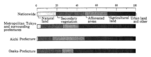
Source : Environment Agency, Vegetation Survey The Third National Survey on the Natural Environment
Note : The Survey was carried out from 1983 to 1986
Public bodies are carrying out a variety of initiatives by issuing regulations to control environmental changes and by establishing public parks and green areas through the designation of areas as natural parks, protected forests, and green conservation areas.
The advance of urbanization, which is resulting in land being covered with concrete and man-made structures, along with the spread of heat-emitting heating and cooling equipment, is producing a heat island effect and increasing aridity. The result is perceptible changes in climate that are having effects on ecosystems (for discussion of the heat island effect, Section 8 of this Chapter). For example, the hemp palm, which is originally a plant found in warm regions, can be seen here and there in Tokyo, and pet wakakehonsei parakeets, which are tropical birds that have escaped from their cages, have also been observed propagating in the city. Effects from increasing aridity are also suspected ; it has been suggested that the phenomenon of the loss of cedars, which can be observed in temple and shrine groves and in farm woodlots in the Kanto Plain, is attributable to increasing aridity, which tends to weaken cedars as they are somewhat deficient in water-absorption capability.
In contrast, some animals, like the Asian House Martin, which lives in mountainous regions, and the white wagtail, which is a winter bird, have in recent years expanded their habitats by adapting to environments on the periphery of cities. Other changes to ecosystems involve a gradual migration from environments on the periphery of cities to urbanized areas.
G. Agricultural Mountain Villages
Agriculture produces agroproducts through human intervention on natural ecosystems. It is an activity that is beneficial to humans, although it does have an impact on the natural environment. The application of agricultural chemicals, fertilizers, and other things is indispensable to agriculture ; however, it is feared that an overdependence on such things could well increase the load on the environment. In contrast, agriculture conducted from the perspective of long-term stewardship leaves an imprint of the natural ecosystems on the agricultural land and surrounding areas. The most representative form of agriculture in Japan is wet paddy rice cultivation. The long tradition of this type of agriculture, involving irrigation channels, pond reservoirs, and paddy levees, has led to the generation of unique ecosystems, inhabited by frogs, loaches, dragonflies, fireflies, and other familiar creatures.
The repeated cutting of wood for charcoal and fuel and the gathering of fallen leaves for fertilizer in the vicinity of mountain villages has resulted in the so-called village-vicinity forest cover, consisting of Konara oak, Kanagi oak, and red pine. An extensive number of bird species, including Chinese little bittern, brown hawk owls, and other bird species as well as gifuchou, usubashirochou, and other butterfly species, have been found in the resulting habitats, and it is known that many unique ecosystems are formed in these habitats by life forms that are familiar to us (Figure 4-5-13).
Fig. 4-5-13 Vegetation Frequented by Several Species
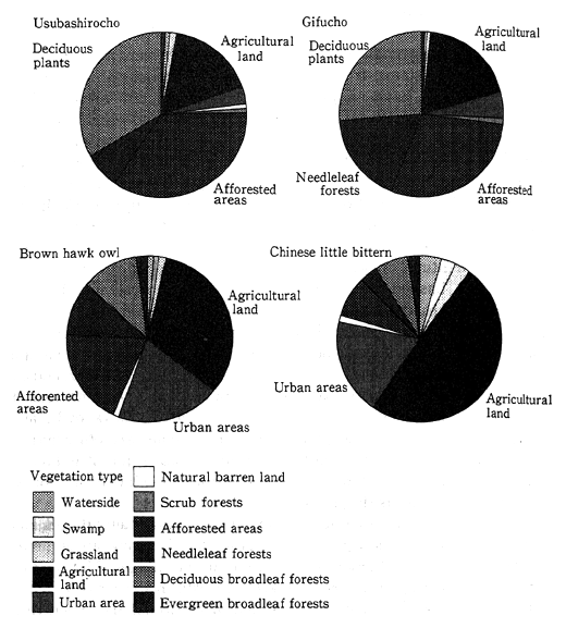
Note : The analysis was carried by mesh units. Therefore, it is necessary to interpret the statement "The various species" habitats were easily verified because of the various types of vegetation in most of the areas observed." For example, it is necessary to interpret "habitats were verified in agricultural land" as meaning "habitats were easily verified in most of the agricultural land observed."
Reference : Comprehensive Report, the Third National Survey on the Natural Environment
Nowadays, the reduction in population of mountain villages and the advance of labor-saving mechanization are bringing about great changes to the natural environment of mountain villages. The hand of man is disappearing from the secondary forests in the vicinity of the villages due to the disuse of charcoal and of firewood, and underbrush is proliferating. It is possible to discern in this process a shift to a more natural pattern of vegetation ; however, it is necessary to carry out appropriate cutting of underbrush in order to preserve the secondary forests in the vicinity of the villages in their previous state.
The fields located along rivers in the bottom of mountain valleys, together with the woods that surround clusters of paddy fields, are home to particularly rich ecosystems but are easily abandoned for lack of profitability because they are often located in remote mountain regions, and such fields are expected to be subject to change. Moreover, future changes in agriculture may have major effects on the natural environment of mountain villages. To preserve the natural environment of mountain villages, regions will be designated as natural parks and protected forests, and efforts will be made to promote environmentfriendly agriculture that reduces the load on the environment.
(3) The Status of Natural Ecosystems in the Developing Countries
A. Forests
In recent years, interest has risen to an unprecedented degree regarding the sharp decline in forests that are located in tropical regions in developing countries.
The reasons commonly cited for the decline in tropical forests are (1) nontraditional slash-and-burn cultivation, (2) excessive gathering of wood for fuel, (3) inappropriate commercial logging, and (4) free-range overgrazing. Behind these immediate reasons are socioeconomic factors in developing countries such as poverty, increasing population, and land use and tenure systems.
Tropical forests play important roles in absorbing carbon and adjusting the earth's radiation and the water balance, and as such they have a powerful role in conserving biodiversity. The steep decline in tropical forests in recent years is giving rise to fears not only of the loss of precious forest resources but also that a number of species that live in the habitats provided by the forests may be driven to a state from which they can not recover. It is thought that some 50-80% of the organisms existing on the earth live in tropical forests, and it is feared that the decline in tropical forests will either cause the extinction of some species or at least shrink their habitats to the point where continued existence is difficult.
Table 4-5-9 Status of World Forest Resources

Forest areas as of 1991
Source: FAO, Production Yearbook 1992
Forests cover about one-third of the earth's surface. The earth's forest cover is estimated at 3.86 billion ha as of 1991. A total of 2.11 billion ha of forest, or 54.74% of the earth's total forest cover, is found in the developing countries, consisting of 550.3 million ha in the Near and Far East, 887.6 million ha in Central and South America, 631.9 million ha in Africa, and 43.9 million ha elsewhere (Table 4-5-9).
According to the final report of the 1990 Forest Resource Assessment announced by the FAQ (Food and Agriculture Organization of the United Nations), the total surface area of tropical forests amounted to 1.76 billion ha as of the end of 1990, compared with 1.91 billion ha at the end of 1980. This means that the area of tropical forests declined by 15. 4 million ha over the 10 years in between (an average annual decline of 0.8%). An examination of the area of tropical forests by region shows that Central and South America lead with 52% of the total, followed by Africa with 30%, and Asia-Oceania with 18%. The average annual decline in tropical forests is 7.40 million ha, or 0.8% in Central and South America, 3.90 million ha, or .2%, in Asia, and 4.10 million ha, or 0.7%, in Africa (Table 4-5-10).
Table 4-5-10 Estimated Loss of Forest Area and Deforestation by Region
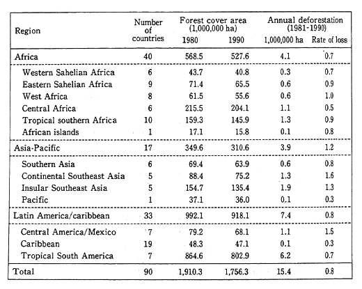
Source : FAO, Final Report on the 1990 Forest Resources A valuation Project, 1993
An examination of the process of forest decline and forest degradation by ecological zone in lowland wet and moist forest zones, lowland dry forest zones, and montane moist forest zones in Africa, Asia, and Brazil is shown in Figure 4-5-14.
Fig. 4-5-14 Forent Cover Changes by Main Ecological Zone (1981-1990)
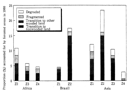
Source: FAO, Final Report on the 1990 Forest Resources Evaluation Project, 1993
Changes to forested areas are classified into four groups : (1) degradation (decrease in canopy density or increase in perturbation), (2) fragmentation (resulting in loss of two-thirds of the original forest area), (3) deforestation due to a shift from forest to other woody land (loss of forest by change of its physiognomic characteristics or transition to short fallow agriculture), and (4) deforestation due to a shift from forest to non-woody land (complete loss of woody biomass and/or conversion to permanent agriculture).
In these three regions (Africa, Asia, and Brazil), there is a high rate of deforestation, forest fragmentation, and degradation in moist lowlands. In contrast to Africa and Asia, where deforestation is in the initial stage of fragmentation and degradation, in Brazil virtually all the forest on the land affected by the change has been lost and the land is rapidly becoming nonforested. This reduction in tropical forests is having a number of negative effects, including the near extinction of many species of wildlife due to extensive loss of habitat. Additionally, it is feared that increasing CO2 emissions due to the loss of forests could accelerate global warming.
Forests, as one type of terrestrial biome, have forest biomass, which is the source of a variety of resources including wood, fuel, and feeds. Also, forests have the greatest capacity to fix carbon in their woody fibers and leaves of the forest canopy. In fact, approximately 50% of the forest biomass is thought to consist of carbon. Also, forest biomass is discussed in much useful scientific literature which attests to the constructive, functional characteristics of forest ecosystems under a variety of environmental conditions.
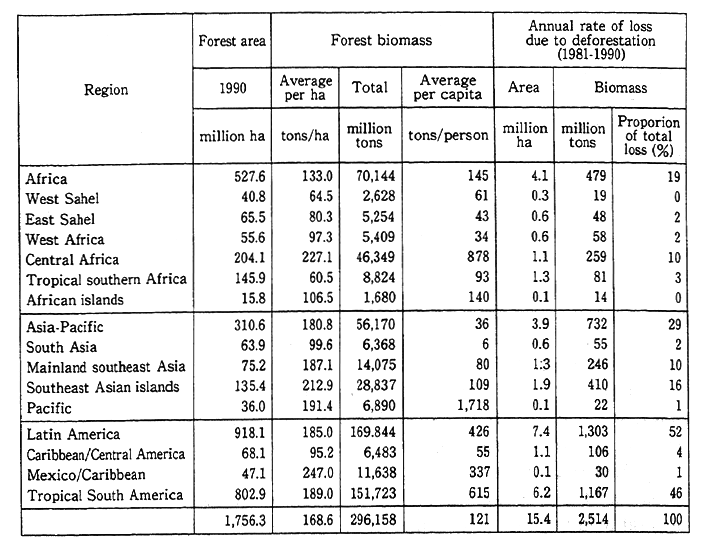
In the Caribbean Sea region, central Africa, and the islands of Southeast Asia, the forest biomass can exceed 200 tons per hectare. In contrast, the lowest corresponding values for forest biomass are found in the Tropical Southern Africa and the African Sahel. The biomass per person is extremely low in Southeast Asia due to population pressure (Table 4-5-11).
The annual loss of forest biomass is estimated to amount to more than 2.5 billion tons. Of this figure, more than 50% is in South America, approximately 30% in tropical Asia, and about 20% in tropical Africa.
Two international organizations, the International Tropical Timber Organization (ITTO) and the FAO, are promoting bilateral cooperation and collaboration in regard to the loss of forests, especially tropical forests. In addition, in January 1994 the new International Tropical Timber Agreement (ITTA) was adopted including the year 2000 objective that states "To enhance the capacity of members to implement a strategy for achieving exports of tropical timber and timber products from sustainably managed sources by the year 2000."
Table 4-5-11 The Status of the World's Forest Biomiass and Annual Rate of Loss due to Deforestation
Source : FORIS data base
Source: FAO, Final Report on the 1990 Forest Resources Evaluation Project, 1993
B. Soils
The soil is the foundation of economic activities like agriculture and livestock raising. The degradation and loss of the soil not only make such economic activities difficult but profoundly affect human existence.
Due mainly to the poverty in the Sahel region, as well as other local areas in Africa, and in the absence of appropriate policies and measures to secure fuel other than trees or to increase agricultural income, the people often cut trees excessively, overgraze beyond the renewability of grasslands, and shorten the intervals between cultivations, which cause further degradation and loss of soil.
Thus, when drought occurs, the inhabitants of the region become environmental refugees and flee to other areas or wander into the cities because they have no wherewithal to withstand such natural adversities. The problem of desertification is linked closely with the problem of poverty. The two main factors causing the degradation or loss of soil are thought to be the climatic-shifts in arid regions due to changes in the circulation of the atmosphere on a global scale-and human-human activities exceeding the permissible limits for sustainability of fragile ecosystems of arid and semiarid areas.
According to a report entitled Status of Desertification and Implementation of the United Nations Plan of Action to Combat Desertification, issued by UNEP in 1991, more than 6.11. billion hectares, nearly 40% of the Earth's land area, is dryland. Of this, about 0.9 billion hectares are hyper-arid deserts. Part of the remaining 5.2 billion hectares have become deserts through human degradation. These lands are the habitat and the source of livelihood for about one-fifth of the world' s population. According to the assessment carried out in 1991, about 70% of the agriculturally used drylands (about 3.56 billion hectares) is currently threatened by desertification. The continents where the proportion of land degradation is greatest are North America, Africa, and South America in that order ; however, in terms of actual degraded area subject to deterioration, Asia leads, followed by Africa.
Regions where the soil is degraded comprise 1.1383 billion hectares, and these regions, including hyper-arid areas, account for 18.3% of total arid regions. Erosion caused by rain is the most common of the various types of soil degradation. This is followed by wind erosion, chemical degradation such as salinization and increasing alkalinity, and physical degradation such as waterlogging (Figure 4-5-15). An examination by continent shows that Asia leads in affected surface area, followed by Africa and Europe in that order. However, Africa leads by far in terms of the percentage of drylands subject to soil degradation (81. 1%). In other words, in about 80% of Africa's drylands the soil is degraded.
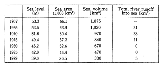
According to a white paper on the environment issued in 1988 by the former Soviet Union, 6,000,000 hectares of agricultural land in that country were subject to waterlogging. Furthermore, with precipitation causing a loss of 1.5 billion tons of rich soil every year, the loss of soil has become a major issue. For example, in the Aral Sea region of the former Soviet Union, a primitive form of irrigation is used to support livestock grazing and agriculture. In recent years, the volume of water in the Amu Darya and Syr Darya rivers flowing into the Aral Sea has been reduced drastically due to the intensive irrigation of cotton fields. According to a UNEP report, the water level of the Aral Sea fell about 14 meters during the period from 1957 through 1989, the sea area declined by about 30 square kilometers, and the lake lost approximately one-third of its water (Table 4-5-12).
Table 4-5-12 Hydrological Parameters of the Aral Sea (1957-1989)
Source : UNEP, World Atlas of Desertification
This has led to severe aridification and salinization to the soil in the deltas of the Amu Darya and Syr Darya rivers, which has in turn severely damaged the ecosystems of the Aral Sea region, including the wildlife and vegetation, and has affected several hundred thousand hectares of irrigated land with salinization. The fertility of much of the cotton farmland has been lost, and the production of major agricultural products has declined. A number of infrastructure deficiencies have arisen, including a serious shortage of medical facilities and a tack of central water treatment facilities, and the health of the local population has deteriorated. Moreover, the land which appeared because the water level of the Aral sea fell is subject to wind erosion and its saline is picked up by the wind and carried as far as 200 kilometers. This, of course, is another factor of land degradation.
To combat the problem of desertification, governments commenced negotiations in May 1993 with the goal of adopting the International Convention to Combat Desertification by Jun e 1994.
Japan's approach to the issues of soil degradation and desertification has hitherto largely been from the perspective of promoting forestation and agriculture in drylands. However, to deal properly with international trends, Japan needs to strengthen its approach to the issue of desertification and move ahead with multilateral and bilateral cooperation to combat desertification.
C. The Antarctic
The Protocol on Environmental Protection to the Antarctic Treaty, which was adopted in Madrid, Spain, in October 1991, stated in its preface that a "Comprehensive regime for the protection of the Antarctic environment and associated ecosystems is in the interest of mankind as a whole." Antarctica, the scene of scientific observations and research, is the only continent largely free from human development, and as such its precious environment and ecosystems should be protected now and in the future.
The region covered by the stipulations of the Antarctic Treaty is defined as those areas at or south of 60-latitude. This region covers a total surface area of 52.5 million km2, of which 14.0 million km2 are land and 12.05 million km2 are Antarctica. The average temperature in Antarctica is - 50 degree C, and 98% of the continent is covered with an ice sheet, which has an average thickness of 2,450 meters. Human activities in Antarctica are limited, both by the severe climate and by the Antarctic Treaty, to survey and research.
Despite the severe natural conditions, the Antarctic region supports a number of ecosystems. The land that is exposed between ice sheets during the summer is habitat for algae and other organisms. In addition to the two known vascular plant species that live in Antarctica, various species of fungi, algae, and bryophytes exist. Some bird species also use certain land areas of Antarctica as breeding grounds. It is known, for example, to provide breeding grounds for around 15 species of birds, including penguins. No mammals are found on the land area; the Antarctic Ocean, however, provides a habitat for six species of seals, and fur seals; Blue whales and five other species of baleen whales ; and Sperm whales, Orca whales, and eight other species of toothed whales. About 65 species of birds and more than 120 species of fish and krill are present in the Antarctic Ocean. These organisms form stable, precious ecosystems in the midst of the Antarctic environment.
Antarctica plays a key role as a site for weather observation and research on earth physics, as indicated by the term "the continent of science," which is sometimes applied to the Antarctic. Research on the ozone hole and analyses of the ancient atmosphere from ice core samples are making steady progress based on observation data from Antarctica. The ice sheet covering Antarctica provides a continuous record of ice since many thousands of years ago. The interior of this ice sheet, consisting of layer after layer of ancient ice, preserves well aerosols and gases that provide a variety of data on the climate and environment of past ages. It is possible to learn about the composition of the atmosphere of the past by extracting air bubbles frozen into the ice. In figure 4-5-16, in which trends in concentrations of carbon dioxide over the past 200 years are shown, a close quantitative link to the results of recent continuous observations in Hawaii is apparent.
Fig. 4-5-16 Ancient Climate and Environments as Recorded in Ice Sheet Cores
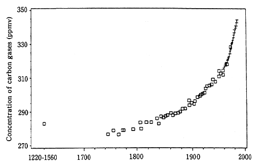
Note : Shows changes in CO2 concentrations over the past 200 years based on thinlayer cores from the Siple base in Antarctica. The boxes indicate core analysis values from Antarctic observation points, while the plus signs indicate observation values recorded at Mauna Loa Island, Hawaii (Friedli, et al., 1986).
Source : National Institute of Polar Research : Antarctic Science I
Fig. 4-5-17 Trends in Tourism to Antarctica
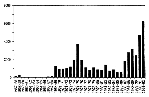
Source: D. Enzenbacher, Scott Polar Research Institute, Cambridge
Under the Antarctic Treaty, human activities in the Antarctic are practically limited to scientific studies. Preservation of the Antarctic environment is being further supported by a number of recommendations including the Agreed Measures for the Conservation of Antarctic Fauna and Flora.
The number of visitors to the Antarctic has been increasing in recent years (Figure 4-5-17), and this trend is foreseen to continue. As a result, the volume of refuse generated at observation bases is becoming an issue.
4-6 The Status of the Diversity of Wildlife
(1) Current State of Wildlife
A. Endangered Species in Japan
Japan's natural environment is quite rich, reflecting the country' s diverse climate, geographical makeup, and position. Wildlife, reflecting this diversity, is present in a great variety of habitats and breeding conditions. Wildlife species are valuable sources of information on the species itself and on the process of the evolution of the species. These species, as constituent elements of ecosystems, support the circulation of substances and the flow of energy, and the balance of ecosystems is maintained by their diversity. Moreover, people use wildlife in a variety of ways: as food, as material for utensils, and for scientific study, education, recreation, and art
However, when there is reckless fishing and hunting of wildlife, or when the growth of human socioeconomic activities leads to destruction of wildlife habitats, sustained pressure on wildlife can lead to the reduction of a population and eventual extinction. Once a species has disappeared, the hand of man cannot recreate it. There is an urgent need to prevent the extinction of species, both from the perspective of the protection of ecosystems and to maintain the various values possessed by wildlife.
To deal with these issues, on April 1, 1993, the government implemented the Law for the Conservation of Endangered Species of Wild Fauna and Flora in an attempt to systematically conserve species of endangered wild animals and plants at home and abroad.
Under this law, the following steps may be taken in regard to species living in Japan that are in danger of extinction. A wild animal or plant may be designated as a National Endangered Species ; it may then be subjected to measures governing its acquisition and transfer as well as to measures to conserve its habitat and to promote protection and propagation programs. In addition to the 38 species of birds that have already been designated under the law, another six species of animals and plants have been added, including the Tsushima Wild Cat (Felis euptilura), the Iriomote Wild Cat (Mayailurus iriomotensis), Tanakia tanago, Libellula angelina, Cypripedium macranthum (var. rebunense) and Callianthemum hondoense.
(i) Animal Species
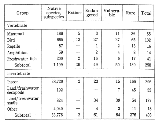
The Environment Agency undertook a study entitled Emergency Survey to Select Species of Animals and Plants that Need Protection to identify native Japanese species of animals and plants that were in danger of extinction, and in 1991 issued Japanese Wildlife in Danger of Extinction (Red Data Book of Japan) based on the results of this survey. The number of species (including subspecies) studied in this survey were 188 mammals, 665 birds, 87 reptiles, 59 amphibians, 200 freshwater fish, 28,720 insects, 192 decapods, 824 land or freshwater snails, and another 4,040 species of invertebrates.
These species were selected according to the degree of danger to the continuation of the species.
Species selected as in danger of extinction were classified into three categories: (1) Endangered (E), species in immediate danger of extinction, (2) Vulnerable (V), species that will be in danger of extinction in the near future if present conditions continue, and (3) Rare (R) species that could easily become "E" or "V" species due to changes in living conditions.
A total of 110 species were listed as "E." These included mammals such as the Japanese River Otter (Lutra nippon) and the Iriomote Wild Cat ; birds such as the short-tailed Albatrus (Diomedea albatrus), the Japanese Crane (Grus japonensis), the Pryer's Woodpecker (Sapheopipo noguchii), and the Blakiston's Fish Owl (Ketupa blakistoni blakistoni) ; amphibians and reptiles such as the Hokuriku Salamander (Hynobius takedai) and the Kikuzato's Brook-snake (Opisthotropis kikuzatoi) ; freshwater fish such as Plecoglossus altivelis ryukyuensis, Tanakia tanago, and Pungitius sp. A total of 114 species were listed as "V," including the Hawkerユs Least Shrew (Sorex minutissimus hawkeri), the Peregrine Falcon (Falco peregrinus japonensis), the Japanese Marsh Warbler (Megalurus pryeri pryeri), the Yellow-marginated Box Turtle (Cuora flavomarginata flavomarginata), the Ishikawa's Frog (Rana ishikawae), and Hucho perryi. And 415 species were listed as "R," including the Erabu Flying Fox (Pteropus dasymallus dasymallus), the Japanese Dormouse (Glirulus japonicus), the Sea Otter (Enhydra lutris), the Common Green Turtle (Chelonia mydas), and Lampetra tridentata. Another 22 species were recognized as having become extinct, including the Japanese Wolf (Canis lupus hodophilax), the Japanese Sea Lion (Zalophus californianus japonicus), the Rufous Night Heron (Nycticorax caledonicus crassirostris), and Pungitius kaibarae (Table 4-6-1).
An examination of the number of species that are either "Extinct (Ex)," "E," "V," or "R" shows that 55 are mammals, 132 are birds, 16 are reptiles, 14 are amphibians, 41 are freshwater fish, 206 are insects, 52 are land and freshwater decapods, and 127 are land or freshwater snails. Except for the insects, which comprise the largest proportion of species selected for inclusion in these categories, no particular species accounts for 15% or more of the total.
The causes for these species becoming extinct or being placed in danger of becoming extinct typically stem from reckless fishing and hunting or other changes, such as in vegetation or water quality due to human activities that lead to deterioration or loss of the habitat. It is clear that the wildlife habitats in Japan are facing severe challenge.
Some species have recovered from the brink of extinction. For example, in 1952, the Japanese Crane population in Hokkaido was down to 33 birds ; however, as the result of protection propagation programs, the population was up to 179 birds in 1970 and had reached 628 in 1994 (566 adults and 62 fledglings). Moreover, the Short-tailed albatrus, which was thought to have become extinct, was rediscovered in 1951 on Tori-shima Island.
Since then, it has reestablished itself, and its numbers are currently estimated at some 600 birds. Programs to protect and further increase its numbers are under way. In view of the fact that the breeding grounds of the albatrus are on insecure, steep slopes subject to rock slides, these programs include steps to establish new breeding grounds and improve existing grounds.
Table 4-6-1 Number of Endangered Species in Japan
Source: Environment Agency, Emergency Survey to Select Species of Animals and Plants that Need Protection
Note : Figures include species and subspecies
The number of native species and subspecies is the number recognized by name in taxonomic studies.
Extinct: Species and subspecies that are thought to be extinct in Japan.
Endangered : Species and subspecies that are thought to be on the verge of extinction in Japan.
Vulnerable: Species and subspecies that could become extinct in Japan.
Rare: Species and subspecies whose base of existence is fragile.
(ii) Plant Species
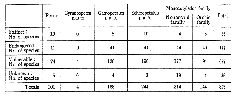
According to the Emergency Survey to Select Species of Animals and Plants that Need Protection carried out by the Environment Agency, Japanese indigenous plants (including species, subspecies, variants, varieties, and subvarieties) includes 8,118 vascular plants, 1,850 algae, 1,516 lichens, 535 mosses, 2,295 spore-propagating lichens, and about 10,000 kinds of fungus.
According to a report produced by the Nature Conservation Society of Japan and the World Wide Fund for Nature entitled The Status of Important Protected Plants in Japan, 147 plants (including subspecies and variants) are endangered, 677 plants are vulnerable, 36 plants are in danger, however, their current status is unknown, and 35 plants have already become extinct. The species that are in danger of becoming extinct account for 16.8% of the approximately 5,300 plant species that were investigated (Table 4-6-2).
Table 4-6-2 Species of Plants in Danger of Extinction
Source : The Status of Important Protected Plants in Japan, 1989
Edited by the Species/Family Subcommittee, Investigative Committee on Important Protected Plants and Communities in Japan; published by the Nature Conservation Society of Japan and the World Wide Fund for Nature
There are many reasons why so many species native to Japan are in danger of extinction. These include the deterioration of the environment along with development, the disappearance of habitats, and overharvesting of wild plants, particularly alpine flora, for personal or commercial use. Loss of habitat may be attributable to factors beyond simple physical destruction; it may also be due to changes in the environment surrounding the habitat, in other words, caused by inattention to the state of local ecosystems.
B. The Status of Wildlife in Japan
By species of animal, Japan is home to 188 recognized species (including subspecies) of mammals, 665 species of birds, 87 species of reptiles, 59 species of amphibians, 200 species of freshwater fish, 28,720 species of insects, 192 species of spiders and other arachnids, 824 species of land and freshwater mollusks, and other invertebrates for a total of 4,040 species. By plant species, Japan is home to 8,118 recognized species (including species, subspecies, variants, varieties, and subvarieties) of vascular plants, 1,850 species of algae, 1,516 species of lichens, 535 species of mosses, 2,295 species of lichens, and about 10,000 species of fungi.
While these numbers are small compared with those of a number of mega-diversity countries, it is clear that Japan enjoys quite high levels of species diversity compared with European countries and much of the industrialized world. This diversity reflects the wide variety of ecosystems found in Japan due to the country's climatic and topographical conditions, which range from subtropical to subarctic zones, as well as widespread and long-established agriculture and the relative paucity of forests with their rich variety of ecosystems in Europe.
For example, an examination of the composition of Japan's forests limited to only the higher plants reveals that of the some 25,000 species (excluding subspecies, etc.) of plants worldwide, Japan's forests are home to 5,565 species (4,770 angiosperms, 44 gymnosperms, and 751 ferns, of which 1,950 are endemic to Japan, excluding subspecies, etc.). An examination of the higher plant biota of other regions equivalent in size that are located at about the same latitude as Japan reveals that the northeast of North America supports 2,835 species and New Zealand 1, 871 species. Japan thus has a highly diverse and rich plant biota compared with these regions.
Illustrating the environments in which wild animals live, an examination of the number of habitats and types of regions various species of mammals, birds, and butterflies inhabit is presented in Table 4-6-3.
As shown in Table 4-6-3, the majority of mammals and butterflies live in mountain regions and most birds live in both mountain regions and plains. Most mammals occupy mountainous habitats that offer extensive space and a wide variety of natural conditions, while birds show a tendency toward hilly and level habitats, from areas that are predominantly water to those that are forested, that support a wide range of natural conditions, including human disturbed environments. Most butterflies tend to inhabit mountainous areas that offer a wide variety of vegetation and forest structures.
Many of the plant and animal species found in Japan are not limited to Japan in their ranges but are often found elsewhere, underscoring the fact that nature knows no borders.
Japan is an important stopping point in the routes of migratory birds, most of which come from Siberia. More than 60% of the birds seen in Japan, including those that migrate within Japan, are migratory birds.
Table 4-6-3 Classification of Topographical Regions with Highly Diverse Animal Biota
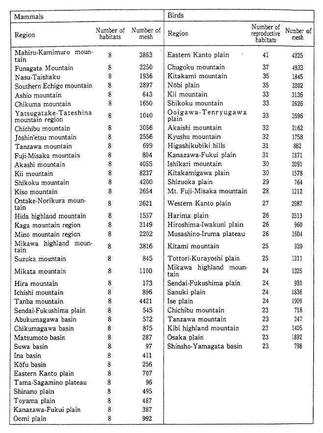
Note : Region classifications that have rich indicators (9 species of mammals, 55 species of birds). There were 38 areas in which the most mammals (8 species) were seen and 30 areas in which more than 23 species were seen. One Mesh is about 1 km2
Reference: Comprehensive Report, the Third National Survey on the Natural Environment, 1989, Environment Agency
In a January 1994 Census of Waterfowls (ANATIDAE), the total number observed was 1,935,000. Of this figure, 95.3% were ducks, 2.85% were swans, and 1.8% were geese. A total of 54,688 swans of four species were observed at 428 sites located in 31 prefectures throughout Japan. Most of these sightings were in Tohoku, Niigata Prefecture, and Hokkaido. A total of 34,846 geese of six species were observed at 634 sites in 20 prefectures. Most of these sightings were in Miyagi and Niigata prefectures. Sightings of ducks were most common-29 species for a total of 1,845,651 ducks-particularly in Niigata, Aichi, Chiba, Yamagata, and Shimane prefectures (Figure 4-6-1).
Fig. 4-6-1 Yearly Trends in Swan and Goose Populations
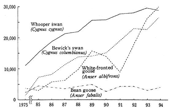
Source: Environment Agency
As part of international cooperative efforts aimed at protecting migratory birds and their migration routes, bird-banding and satellite tracking surveys are being undertaken to better define these routes. Thanks to the surveys, many of the routes passed by migratory birds have been identified, such as the route taken by the Latham's snipe (Gallinago hardwickii) from Australia and the swallow (Hirund rustica) from Southeast Asia. In addition, the route of the white-naped crane (Grus vipio) and hooded crane (Grus monacha) from Korea and China and the route of the Bewick's swan (Cygnus bewickii) from Siberia have been tracked. These results contribute to the bilateral conventions and agreements for the protection of migratory birds and their habitats and contribute to the study and research of these creatures.
In addition, because migratory birds cross borders, their numbers will decline unless all the countries that they pass establish suitable protective measures. For this reason, Japan is working to establish relevant conventions or agreements with the United States, China, Australia, and Russia.
Two species of bears are native to Japan: the brown bear and the Asian black bear. However, the habitat of bears has undergone great changes in recent years, reflecting abrupt socioeconomic changes that have affected the natural setting of Japan. The Asian black bear is the largest mammal on Honshu, and its welfare is most representative of the states of ecosystems of temperate forests. It is feared that local populations of this bear, in the western parts of Honshu, Shikoku, and Kyushu are in danger of becoming extinct, and appropriate measures and controls are being sought at home and abroad. Prohibition on the international trading of this bear is contained in appendix I of the CITES.
Fig. 4.6-2 Areas Inhabited by the Asian Black Bear in the Tanzawa and Dai Bosatsu Mountain Regions along with Boundaries of Cities and Townships
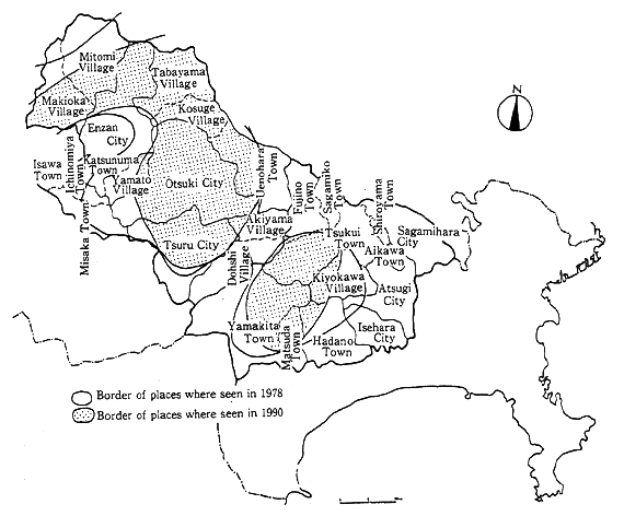
Source: Environment Agency
According to the results of a survey undertaken by the Environment Agency, the ecologies of areas inhabited by bears have deteriorated in the last few decades. In many areas, forests have become fragmented due to such human activities as construction of roads and the development of residential areas. In the case of the Asian black bear, its range has become limited to a few isolated areas as a result of a deterioration of much of its natural habitat.
For example, Figure 4-6-2 shows the areas inhabited by the Asian black bear in the Tanzawa mountain region. A comparison of the extent of habitat in 1990 with the habitat revealed in the Second Basic Survey of the Natural Environment made in 1978 leads to the inference that the bear's habitat is gradually becoming fragmented due to road and other construction.
C. The Status of Animal Habitats Overseas
The numbers of vascular plants and vertebrates are relatively well known. In contrast, however, the knowledge of insects and invertebrates is relatively little. The total number of species on the earth is estimated at between 5 million and 50 million. At present, the number of documented species stands at about 1.4 million. Tropical forests account for no more than 7% of the earth's land surface ; however, more than half the world's species are found in tropical forests.
In Table 4-6-4 are shown the countries that are known to harbor many species of mammals, birds, amphibians, reptiles, the swallowtail family of butterflies, and angiosperms. From the table it is clear that countries boasting tropical forests, such as the countries of South America, Indonesia, and Zaire, support the highest numbers.
Countries that support a great many species, especially endemic species, are said to possess mega-diversity. Twelve such countries are Brazil, Colombia, Ecuador, Peru, Mexico, Zaire, Madagascar, Australia, China, India, Indonesia, and Malaysia. It is thought that between 60% and 70% of all the species on the earth may be found in these twelve countries alone. Brazil, Columbia, Indonesia, and Mexico are particularly rich in their number of species, while Australia and Madagascar are home to many endemic species, though the total number of species is not so great. Countries like China and Brazil host a large number of species due to their large size, and countries like Ecuador, Madagascar, and Malaysia that have highly varied topologies are highly rich in their diversity of species even though the countries themselves are not large. It is necessary for the entire international community to cooperate in protecting the extremely rich diversity of life in those countries, rather than leaving the task to those countries alone.
Table 4-6-4 The Ten Leading Countries in Terms of Numbers of Species
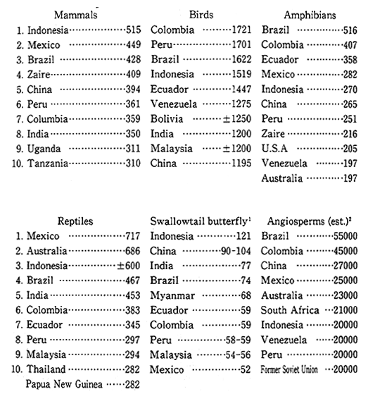
Reference: Conserving the World's Biological Diversity, 1990, published by IUCN, WRI, Conservation International, WWF-US, and the World Bank
Sources : Conservation International and many other sources
Note : (1) Collins and Morris, 1985
(2) Davis et. al., 1986
However, although extremely rich, these biota are losing ground fast due to the destruction of their habitats. According to the 1990 IUCN Red List of Threatened Animals, which surveyed the status of endangered species throughout the world, 2,25O species of invertebrates and 2,751 species of vertebrates were found to be endangered and the habitats of many others threatened. Moreover, other tropical forests, including tropical rain forests, are rapidly disappearing. The World Resources Institute (WRI, 1989) forecasts that from 5 to 15% of the world's species will become extinct in the period from 1990 to 2020, largely due to the destruction of tropical forests. If it is assumed that 10 million species currently exist on the earth, then the WRI's calculations suggest that between 15,000 and 50,000 species will become extinct annually.
Species are constantly undergoing extinction as part of natural processes, but until recently the pace has been extremely slow. Nowadays, however, the pace is proceeding at an unprecedented speed. Moreover, this sharp reduction in the number of species is not attributable to natural processes but largely to human activities, which is why the extinction of species has become a major global environmental issue.
International approaches to the issue, including the Convention on International Trade in Endangered Species of Wild Fauna and Flora (Washington Convention, CITES), are under way to protect wild species that are in danger of extinction. Moreover, in May 1993, Japan became a party to the Convention on Biological Diversity, which is intended to protect comprehensively biological diversity. This convention went into effect in December 1993.
(2) The Status of Wildlife Resources
A. Marine Resources
Marine products have traditionally been an important source of protein for the Japanese people. The volume of production of marine products has grown almost steadily since 1945. In 1981, the fishing industry (excluding fish farming) harvest exceeded 10 million tons and by 1984 reached 11.5 million tons. However, harvests have been decreasing since 1989 and reached a low of 7.77 million tons in 1992. An examination of the trends by major varieties of fish reveals that harvests of sardines, Alaska pollack, and mackerel have been declining (Figure 4-6-3).
Fig. 4-6-3 Trends in the Harvest Volume of Major Varieties of Fish
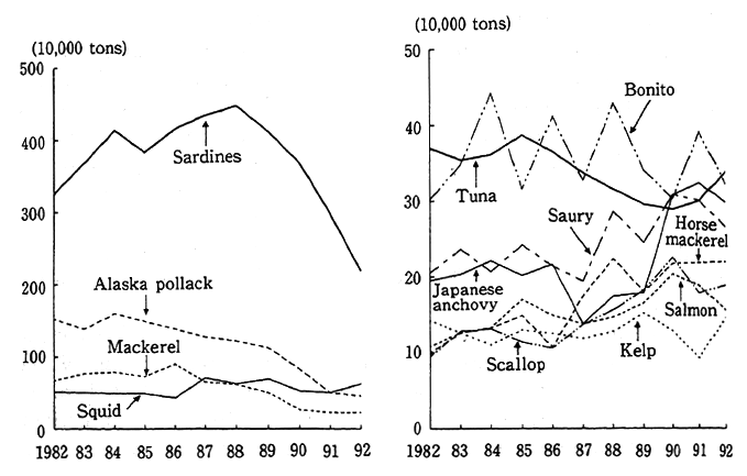
Source: Ministry of Agriculture, Forestry, and Fisheries, Statistical Yearbook of the Fishing and Fish-Farming Industries
The general volume of the demersal fish in the waters adjacent to Japan has declined to low levels due to an accelerated degree of fishing, reflecting improvements in the performance of fishing vessels. Moreover, there is concern that stocks of sardines will continue to decline.
Issues related to the fishing industry and the protection of wildlife are being addressed at a variety of international meetings. At the Eighth Meeting of the Conference of the Parties to CITES (Washington Convention), the Atlantic bluefin tuna was considered in the attached appendix, and there were attempts to place controls on international trade in this fish; however, a proposed motion mandating stronger measures for preservation and control by international organizations overseeing the fishing industry was withdrawn by the forwarding country. Furthermore, western countries sought to establish the whale as a symbol of the environmental protection movement, and antiwhaling activities took a higher profile. Despite these moves, the principle of rational use of marine resources, including whales, was affirmed at the Rio Environmental Summit. The International Whaling Commission is currently the scene of discussions on the harvesting of Minke whales, on allowing coastal whaling operations to begin again, and on establishing a whale sanctuary in the Antarctic Gcean (Figure 4-6-4). Worldwide attention is also being drawn to the issue of the uncontrolled harvesting of marine mammals, sea birds, and sea turtles.
Fig. 4-6-4 Whale Harvests in the Antarctic Ocean from the 19041905 Season through the 1980-1981 Season
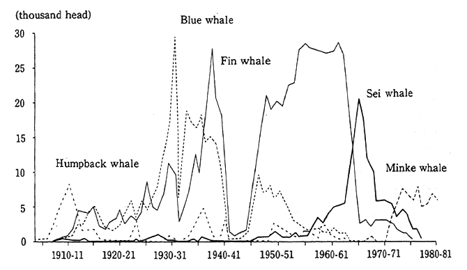
Source: International Whaling Statistics (provided by S. G. Brown)
[P 400]
In 1991, the UN imposed a moratorium on the large-scale use of drift nets by the fishing industry, and in keeping with this decision, Japan had ceased such operations by the end of 1992.
It is essential to maintain the sustainable use of such marine resources as they are a source of wealth for the entire world and are indispensable as a source of food and fertilizer. Therefore, it is important to carry out management of the fishing industry based on scientific data.
B. Hunting
Hunting is carried out as a form of recreation and can also function as a method of keeping the number of wildlife within the carrying capacity of local ecologies.
Game in Japan covers 29 species of birds, including ducks, sparrows, crows, and pheasants, and 18 species of land mammals, including bears, raccoon dogs, and wild boars. The bird catch in 1991 was about 3,110,000, of which eastern turtledoves accounted for 31.2% and spar-rows 23.5%. The land mammal catch was about 350,000, of which hares accounted for 54.4%, wild boars 17.7%, and raccoon dogs 10.4% (Table 4-6-5).
Table 4-6-5 Trends in Major Wildlife Catches
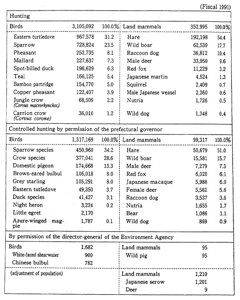
Source: Environment Agency, Statistics on Wildlife for Fiscal 1991
In addition, the controlled hunting of wildlife is promoted in keeping with the objectives of administrative bodies and the directorgeneral of the Environment Agency to control harmful birds and mammals. In 1991, about 1,320,000 birds and about 100,000 land mammals were caught with the permission of prefectural authorities specifically for this purpose. Sparrows led the bird category, accounting for 34. 2%, followed by crows at 28.8%, and domestic pigeons at 13.3%. Hares led the land mammal category, accounting for 51.0% of the catch, followed by wild boars at 15.7%. The total number of wild birds caught was about 4,420,000, and the total number of wild land mammals caught was about 450,000.
The number of hunting licenses issued and the number of animals caught continued to rise through 1976. The total catch in 1980 peaked at about 8,400,000. Thereafter, however, a decline set in, with the catch falling to about 3,460,000 in 1991. An examination of trends in the number of hunters reveals that while there were 530,000 hunters in 1976, by 1991 this figure had fallen to about 260,000, and most of these hunters were well advanced in age.
C. International Transactions
The industrialized countries import foreign animals and plants, especially from the tropics, for appreciation and other purposes. In these countries, changing preference for unusual animals and plants, and improvements in transportation technology have resulted in a growing volume of trade in wildlife from tropical regions, and there are fears that this trade is having a negative impact on the habitats of wildlife.
The Washington Convention (CITES) was signed in an effort to help prevent the extinction of wild fauna and flora due to trade. The convention regulates trade and prohibits international trade in endangered species. In Table 4-6-6, the international trade of the species for which trade is regulated under the convention are shown. The import of wildlife is generally to industrialized countries from mainly developing countries in the tropics.
Table 4-6-6 Trade in Wildlife and Wildlife Products as Reported under the Washington Convention (CITES)(1988)
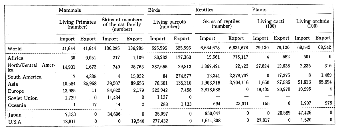
Note : - indicates data is unavailable
Source : World Conservation Monitoring Center
Reference : World Resources 1992-93
In 1989, the Meeting of the Conference of the Parties to CITES (Washington Convention) decided to prohibit trade in African elephants and their ivory in view of around 50% decimation of the species's numbers in the first half of the 198Os due to poaching. This prohibition, combined with other efforts aimed at preservation, was successful, resulting in a dramatic drop in poaching and an increase in the number of elephants. Elephants have now returned, for example, to such regions as northern Kenya, where they were for a time in danger of disappearing. Nonetheless, in certain portions of southern Africa, the elephants are present in such great numbers that managing their numbers and culling are required.
(3) Pollution of Organisms
Pollutants are present in the air, water, and soil, and there is a particular danger of organisms that depend directly on such polluted resources becoming contaminated themselves.
Some organisms accumulate concentrations of toxic heavy metals and chemicals, showing higher levels of pollutants in their tissues than shown by the atmosphere or water of their habitats. Moreover, because contamination levels in organisms serve as monitors of pollutant accumulations, data collected on such levels during a specific period can be highly useful, indicating the cycles of substances in the environment that are thought to pose problems to human health and to ecosystems while facilitating the understanding of trends in pollution level and of the overall efficacy of a variety of antipollution programs.
According to the results of a fiscal 1992 survey of chemicaI in fish, which was intended to assay persistent chemical residues in the general environment and ascertain the levels of concentration of such chemicals, two of the 11 chemicals searched for were detected. Non of the chemicals detected, however, was in concentrations that posed any immediate problem. An examination of the results of continuous monitoring shows that 24 chemical substances have been detected (Table 4-6-7).
In an effort to track the toxic chemical pollution situation since fiscal 1985, studies have been carried out to determine the persistence f dioxins and other toxic chemicals that are produced unintentionally in the environment. The results of a fiscal 1992 study indicatet that general dioxin levels were not dangerous to human health. However, because low concentrations of dioxins were detected, it is essential to continuously monitor the pollution situation (Table 4-6-8).
Table 4-6-7 Results of Monitoring for Chemicals in Organisms in Fiscal 1992 and a Comparison with Fiscal 1991
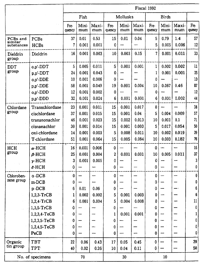
Note : Values for the δ-HCH and the chlorobenzene groups are for fiscal 1990, and the number of specimens was 65 fish, 25mollusks, and 10 birds for a total of 100 specimens.
Source Environment Agency
Table 4-6-8 Survey of Dioxin Levels in Organisms
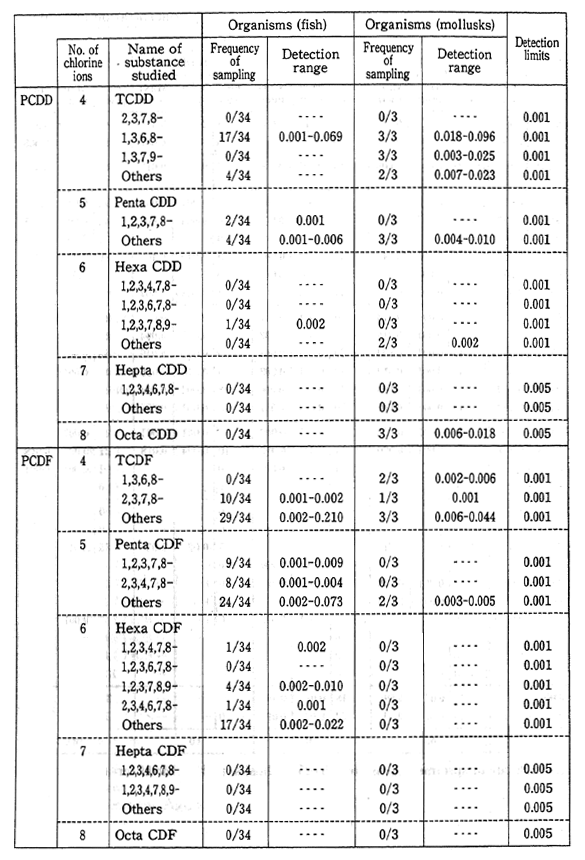
Source : Environment Agency
4-7 Contact with Nature
(1) Emerging Needs
In recent years, demand for opportunities to enhance mankind's habitat with nature has been growing in step with the increase in leisure time, the destruction of natural resources in the vicinity of cities, and a rising interest among Japanese people in the natural environment. Only by coming in direct contact with nature can people enjoy the natural environment. This contact may assume a variety of forms. People may, for example, sense the beauty and grandeur of nature by going to a public park, gain a deeper understanding of nature by joining in the activities of nature study groups, or appreciate the greenery lining streets in cities or the scenery along a river or lake. The opportunity to pursue such activities is essential to educate people to the importance of nature and to revive their sense of humanity.
Natural parks are intended to preserve places of outstanding natural beauty while contributing to the health and relaxation of the people by allowing public access. The number of people visiting parks has been increasing in recent years, reflecting the growing interest among Japanese people in becoming more familiar with nature (Figure 4-7-1). An examination of the total number of visitors to parks indicates that the number remained largely unchanged from 1975 through 1983. Starting from 1984, however, the number increased gradually to total about one billion visitors in 1993.
Breaking down the numbers by the type of park, the number of visitors to national parks was 389,920,000 in 1993 (down 5.6% from the previous year) ; to quasi-national parks, 296,070,000 (down 7.6% from the previous year); and to locally administered nature parks, 269,650, 000 (down 5.7% from the previous year).
In a June 1991 public opinion survey concerning the protection and use of natural resources, of the 79.8% who responded that they "had visited" places abundant in natural beauty, 35.5% stated that the purpose of their visit was "to enjoy beautiful natural scenery," 30.9% cited to engage in mountain climbing or hiking," and 28.0% cited "to relax in a hot spring." In response to the question "Do you want to increase your opportunities to come in contact with nature ?"63.1% stated "Yes, I want to increase such opportunities" and 29.5% stated "Yes, I greatly want to increase such opportunities." It can be safely predicted that the Japanese people's demand for opportunities for contact with nature will increase.
Fig. 4-7-1 Trends in the Number of Visitors to Natural Parks
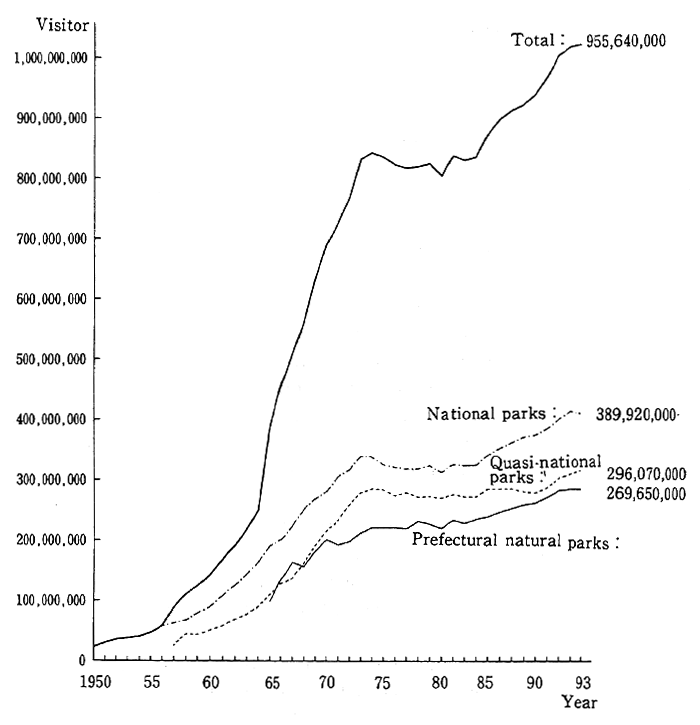
Note Statistics on the number of visitors to quasi-national parks begin from 1957 and of Prefectural natural parks from 1965.
Source: Environment Agency
(2) Sites for Communicating with Nature
A. Setting Aside Sites
Today more than half the Japanese population grows up and lives in the artificial environment of cities, and the only way for people to revive their humanity is to establish communication with a world not shaped by human hands, in other words, areas that support untouched fields and primeval forests, the world of nature. Taking a healthful rest to visit the mountains, the seaside, or other places that are far away, both mentally and physically, from daily life and the city is beneficial. Parks and hot spring resorts are two such places where people can enjoy the riches of nature.
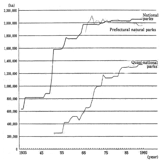
The enacting of the National Parks Law in 1931 and the Natural Parks Law in 1957 provided a framework for the establishment of national, quasi-national, and prefectural natural parks. As of the end of fiscal 1993, land covered by parks totaled 5,325,822ha, amounting to 14. 1% of Japan's area. Breaking this figure down, there were 28 national parks, covering 2,051,312ha ; 55 quasi-national parks, covering 1,332, 882ha; and 301 prefectural natural parks covering 1,941,628ha. An examination of trends reveals that the area covered by national and quasi-national parks doubled between 1931 and around 1975. Thereafter, the area covered has remained more or less the same (Figure 4-7-2).
Fig. 4-7-2 Area Covered by Natural Parks
Source: Environment Agency
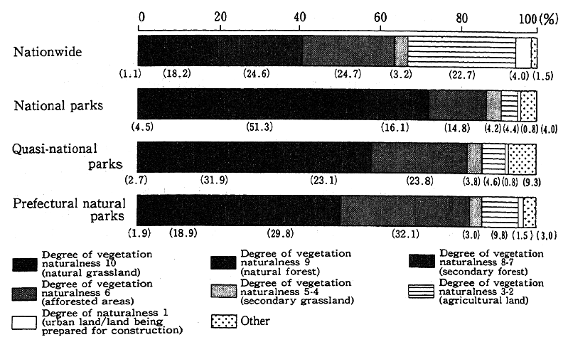
Fig. 4-7-3 Degree of Vegetation Naturalness in Parks
Source : Environment Agency, Vegetation Survey, the Third National Survey on the Natural Environment
In Figure 4-7-3, the composition of nature parks in terms of the degree of naturalness discussed in Section 5 of Chapter 4 is illustrated. A high proportion of nature parks have a vegetation naturalness rating of 10-9, while a lower proportion has a vegetation naturalness rating of 2-1. An examination of forest cover (vegetation naturalness rating: 9-6) by category of park reveals national parks standing at 82.2%, quasinational parks at 78.7%, and prefectural natural parks at 80.8%. These figures run around 80% in all three categories and exceed the national average of 67.5%.
Local ecologies are increasingly being destroyed due to the growth of cities. For this reason, the Environment Agency is providing facilities with such names as Village of the Environment and Culture and Village where People Can Come in Contact with Animals and the Countryside. These are in easily accessible locations where small animals can live and where the local ecology-including greenery, the water, and other environments-is protected. In such places, people can come in contact with nature and gain a deeper understanding of its workings. In addition, long-distance hiking trails are being set up in natural parks with outstanding scenery and in regions of historical and cultural value in the interest of reestablishing the nature walk as a basic means of coming in contact with nature.
Hot springs and spas, which Japanese have always loved as a means of preserving health and providing relaxation, have long played a major role in bringing people into contact with nature. The number of people nationwide who used overnight accommodations at spas reached approximately 143,250,000 in fiscal 1992, an increase of about 400,000 from the previous year. An examination of trends reveals that the number, which had been tapering off after reaching a peak in 1973, began rising again in 1986.
To further the usage of hot springs and spas, the Environment Agency has designated certain spa areas, considered to have excellent natural environments and recuperative effects on people's health, as hot spring health resorts.
In 1985, as part of efforts to revive people's awareness of the pristine waters throughout Japan, especially springs and natural running water, the Environment Agency began to publicize 100 such sites from Rishiri Island in the north to Okinawa in the south. The selection process for the list took into account such factors as the sites' water quality, water volume, surrounding environment, and amenities offered as well as the efforts of the local people to provide a recuperative environment. It is expected that these efforts will heighten interest in the recuperative effects of high-quality water as well as in aquatic environments where people can come in contact with the bounties of nature.
B. Providing for Facilities
Bringing people in contact with nature involves much more than simply providing a natural environment ; the sites for such activities must have facilities that enable enjoyable, safe visits. The Japanese people are increasingly expecting that such public facilities as nature trails and camping sites will be made available.
In addition to promoting development of facilities, in the broadest sense, in national parks, quasi-national parks, and other natural sites close by, the Environment Agency offers support to local administrative bodies to develop facilities. Figure 4-7-4 shows the large increase in recent years in the facilities budget for nature parks.
Fig. 4-7-4 Trends in Facilities Provision Budget for Nature Parks
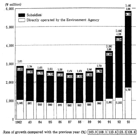
Note : Aigures within square brackets [ ] indicatethe subtotal devoted to enhancing visitor-related facilities.
Source: Environment Agency
Such facilities as nature trails, picnic sites, camping sites, visitor centers, and lavatories are being set up in national and quasi-national parks. Provisions for the establishment of an "ecology camp" were begun in fiscal 1993. These camping sites will provide a model for other environment-friendly campsites at which families can come into contact with nature. It is imperative to actively step up the provision of such public facilities as demand is expected to increase substantially.
In response to the growing popularity of hot spring spas, the Environment Agency selects certain sites as nature-friendly, relaxing spa areas that, thanks to their natural resources, are suitable for nature education and mental refreshment and hot springs as people's recuperation spa areas that are helpful for people's health, with doctors, within health resorts. These sites receive subsidies for the provision of various public facilities.
(3) Contact -with- Nature Activities
It is essential to provide a variety of places and opportunities where people may come into contact with nature. Exhibitions at visitor centers in parks, woods where visitors can enjoy nature tours, and villages where people may come in close contact with farm animals, along with interpretative lectures by personnel, all benefit visitors.
Parks also hold a variety of activities in connection with promoting contact with nature. Gatherings to promote familiarity with nature are held throughout Japan every year on April 29, which is celebrated as Greenery Day, a national holiday. And a campaign to promote familiarity with nature is held during summer vacation from July 21 to August 20. A variety of nature tours and hiking camp rallies are provided by parks nationwide.
The Nationwide Nature Trail Hiking Rally is held in October, which has been designated as the Month for Hiking Nature Trails Nationwide. Figure 4-7-5 shows the trends in the number of courses and participants in the rally. Growth in the size of the rally underscores the steady increase in the number of people taking nature hikes and thus in the number demanding more opportunities for coming in contact with nature.
Fig. 4-7-5 Trends in the Number of Participants in the "National Trail Festival"
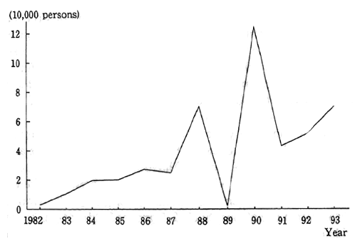
Source: Environment Agency
Local administrative bodies also undertake activities to preserve the environment. The Environment Agency has carried out surveys of relevant regulations and plans issued by cities and townships. A comparison of 371 such instances in the period from 1970 to 1974 and of 190 from 1985 to the present reveals that in the first period the overwhelming majority were for wide-ranging purposes, including the promotion of greenery, the preservation of nature, and the preservation of the environment. In the most recent period there has been an increase in special initiatives, such as the establishment of greenery promotion funds as well as measures to protect scenic beauty, flora and fauna, noted trees, and other aspects of local environments. In recent years there has been a diversification of the types of sites preserved and methods used to preserve the natural environment that reflects a marked increase in demand for more opportunities for contact.
The number of private action groups connected with promoting contact with nature has surged in recent years, as discussed in Section 2 of Chapter 1.
Such organizations are stepping up activities that promote contact with nature. In fiscal 1992-1993, the Environment Agency undertook a methods survey covering metropolitan Tokyo and portions of six prefectures regarding the conservation-oriented plans of such groups. The survey showed that bird-watching and nature study meetings are the most common activities undertaken by such private groups. These are followed by groups promoting outdoor volunteer activities connected with the collection of garbage, the cultivation of greenery, and similar activities. The most common sites selected by these groups for their activities are areas that fit such descriptions as places where people can observe the changing seasons, places with beautiful scenery, and wide-open spaces. An emphasis is placed on sites that offer natural scenery rich in variety where people can view a selection of flora and fauna.
The Environment Agency has been holding star-gazing sessions every summer and winter since 1988. The starry heavens are an important element of natural scenery and have always had great mental and spiritual significance to mankind. In recent years, however, the visibility in skies over urban areas has deteriorated. To raise public awareness of the need to protect the atmosphere, 245 groups held star-gazing sessions nationwide during summer 1993. These sessions were attended by 5,732 people. Reports by the groups concerned shows that they are taking a wide-ranging approach that includes environmental education in addition to star-gazing.
In fiscal 1988, the Environment Agency carried out a nationwide survey of big trees. The number of big trees was estimated at more than 120,000. Big trees have an immense significance in Japan as they serve as symbols of the nation's forests and woods. As such, they are of incalculable value and by forming scenes of great beauty, providing habitats for wild creatures, and serving as regional symbols they encapsulate the bounty of nature. An annual nationwide forum on big trees has been held since 1988 in connection with this survey. The establishment of nationwide associations devoted to preserving big trees testifies to growing public interest. The activities of local administrative bodies and private organizations are expected to play significant roles in nature educational activities centered around big trees that focus on preserving local natural heritage and on creating cities and towns rich in nature.
B. Securing Personnel
As previously pointed out, demand for opportunities to come in contact with nature is growing and the number of visitors to parks is increasing. Today, the relationship between man and nature has become tenuous. This has given rise to a phenomenon in which people do not know how to cope in natural settings even though opportunities and places to make contact with nature are widely available ; failing to understand nature, they can not enjoy it. Therefore, it is essential to secure and train personnel to conduct activities designed to allow people to become familiar with nature, to learn how to come in contact with nature, and to better understand nature.
Rangers at national parks are Environment Agency personnel whose job is to take care of the local management of natienal parks. Planning and implementing nature interpretation activities for visitors to public parks, they number 140 people stationed at 28 national parks nationwide.
In addition, a large number of volunteers are active at national and quasi-national parks. National park guides provide instruction and information to visitors on the preservation of national parks and their proper use. At present, about 2,700 persons are under contract to the director of the Nature Conservation Bureau of the Environment Agency as guides. In addition, volunteers, who provide help in national parks for nature interpretations and cleanup operations, are sought and trained by the national parks' management offices. At present, about 1,300 people are registered as volunteers.
Moreover, regional public organizations also undertake initiatives to seek and train nature interpretation personnel to conduct nature tours and outdoor training sessions held by schools.
4-8 The Status of Other Aspects of the Environment
(1) Heat Island Effect
In addition to the seven major types of pollution, such phenomena as the heat island effect can be observed in metropolitan Tokyo and other metropolitan areas. Cities have dense patterns of energy consumption, and since they are paved with asphalt, concrete, and other nonabsorbent materials, little evaporation of trapped moisture, which lowers temperatures, occurs. Another characteristic of cities is that, relatively, their temperature does not decline much at night because the concrete and other surfaces release radiant energy accumulated during the day from the sun. As a result of these factors, the temperature is higher in the center of a city than in the outlying areas. This phenomenon, which can be demonstrated using a temperature diagram, is called the heat island effect and is quite perceptible in Tokyo and other large cities.
As shown in Figure 4-8-1, the average annual temperature in Tokyo has risen from 14 degree C in the 1870s to around 16 degree C at present. This represents an increase of 2 degree C in about 120 years. Moreover, the average annual humidity in Tokyo has declined from approximately 77% to about 63%, a decline of 14%, and this too is thought to be one of the factors causing the heat island effect.
When the heat island effect takes place, particularly when the rising temperatures of summer touch off increased demand for energy for cooling purposes, the rise in temperatures coupled with poor circulation puts an increased load on the environment. In contrast, temperatures in green areas are somewhat regulated by the plant life, which absorbs the surrounding heat when water transpires from leaves. In addition, rivers, streams, and marine areas within cities play a role in ameliorating the heat island effect. One of the critical issues of the future will be to gain a better understanding of the relationship between urban ecosystems and the heat island effect.
Fig. 4-8-1 Changes over Time in Tokyo's Annual Average Temperature
Source: Meteorological Agency