
- MOE
- National Parks of Japan
- Shikotsu-Toya National Park
- Characteristics
main body
Characteristics
Living Volcanoes and Quiet Blue Lakes: a Museum of Volcanic Activity
Date of Designation: May 16, 1949
Area: 99,473ha
Related Prefecture: Hokkaido
Area: 99,473ha
Related Prefecture: Hokkaido
Located in the southwestern part of Hokkaido Prefecture, Shikotsu-Toya National Park is a park where visitors can see not only see two large caldera lakes -Lake Shikotsu and Lake Toya - but also variously shaped volcanoes and volcanic landforms -such as Mt. Yotei, Mt. Usuzan, and Mt. Tarumae. In addition to a large and diverse range of hot springs, much volcanic activity can also be observed, such as the jigoku ("hell") phenomena of gasses belching from fumaroles, and the park can truly be called a "Living Volcano Museum". One of the benefits of this volcanic activity is the popular and bustling hot springs tourism areas that are representative of Hokkaido Prefecture, including Noboribetsu, Lake Toya, and Jozankei. The breathtaking landscape comprising interweaving lakes, forests, and volcanoes soothes peoples hearts and minds. Lake Shikotsu is also famous for being at the northern limit for non-freezing lakes, and the distinctive deep blue color of the water surface is highly appealing to park visitors.
The park's location close to central Sapporo City and Shin-Chitose Airport makes it easy for many people to visit. In addition to people visiting by private car or tour bus to see volcanic phenomena and experience nature, or on sightseeing tours for hot springs recreation, etc., people come to the park to climb mountains and observe the alpine vegetation.
The park's location close to central Sapporo City and Shin-Chitose Airport makes it easy for many people to visit. In addition to people visiting by private car or tour bus to see volcanic phenomena and experience nature, or on sightseeing tours for hot springs recreation, etc., people come to the park to climb mountains and observe the alpine vegetation.
Terrain/ Scenery
Centered around caldera lakes Lake Shikotsu and Lake Toya - two of Japan's representative caldera lakes -the park contains many volcanoes, such as Mt. Usuzan, which is still active today, and Mt. Yotei, which is a stratovolcano. Springs, Jigokudani, and other volcanic phenomena can also be seen, and the area is dotted with volcanic lakes and marshes, such as Lake Kuttara and Lake Tachibana, creating a volcanic landscape representative of Japan. In 2009, the Toya Caldera and Usu Volcano Global Geopark was certified as a Global Geopark in recognition of the global value of its geological heritage, and thus became the first Global Geopark in Japan.
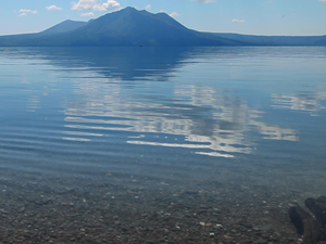
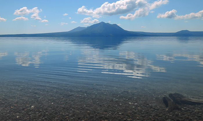
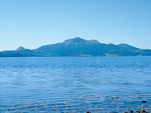
Lake Shikotsu
Lake Shikotsu Area
Calderas were formed by the volcanic activity of the Shikotsu volcano, which began approx. 32,000 years ago. Subsequently, Mt. Fuppushi, Mt. Eniwa, and Mt. Tarumae were also formed, creating today's Lake Shikotsu. While Mt. Fuppushi is already extinct, Mt. Eniwa has been confirmed to have small blowholes in craters below the summit, and Mt. Tarumae remains an active volcano even now. With an maximum depth of 360 m, Lake Shikotsu is Japan's second-deepest lake. In addition to the cold climate, there is little flow of sediment into the lake, enabling it to boast one of the highest degrees of transparency of any lake in Japan.
Mt. Tarumae
Mt. Tarumae is a new volcano, and so there is only forest cover up to around a height of 700 m above sea level. The top of the mountain is covered in communities of alpine plants such as Ledum palustre subsp. diversipilosum var. nipponicum, Alnus crispa subsp. Maximowiczii, Pennellianthus frutescens, and Arcterica nana, creating a distinctive landscape.
Jozankei
Jozankei Area
Jozankei has a mountainous topography comprising relatively old volcanoes such as Mt. Muine, Mt. Soranuma, and Mt. Sapporo. Because these mountains are covered in alpine vegetation and provide superb views, the area makes an excellent one-day hiking trip from around Sapporo. Located along streams flowing into the Toyohira River, Jozankei Onsen is one of Hokkaido's top hot springs resorts.
Lake Toya and Mt. Usuzan
Lake Toya Area
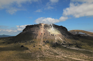
Lake Toya is an almost-circular caldera lake measuring approx. 40 km across. Floating in the center of the lake is Nakajima Island, which was formed through volcanic activity. The area surrounding the lake forms an expansive landscape comprising agricultural land and human settlements. Mt. Usuzan is a volcano that became active approx. 20,000 years ago. Around it are numerous lateral cones, and in particular Mt. Showa-Shinzan -which was created through volcanic activity between 1943 and 1945 -is said to be a lava dome and has high value in both academic and scenic terms. In addition, Toyako Onsen was born when a wellspring opened up on the shore of the lake after the volcanic eruption of 1910.
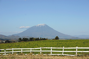
Mt. Yotei
Mt. Yotei Area
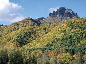
Rising to a height of 1,898 m above sea level, Mt. Yotei is a typical free-standing stratovolcano; it is also referred to as "Ezo-Fuji." The landscape is characterized by the mountain's graceful slopes and vegetation, and pronounced changes in the vertical distribution of vegetation communities can be seen. The view from the summit is especially spectacular. A typical vertical distribution of vegetation can be observed on Mt. Yotei, where broad-leafed forest at the foot of the mountain gives way to coniferous forest in the center, and then alpine plants such as Yellow-flowered Rhododendron and Blue Mountain heath blooming at the summit.
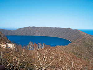
Lake Kuttara
Noboribetsu Area
In Noboribetsu, volcanic activity can still be seen today in Jigokudani and various other places, and some of the best and abundant hot spring fountainheads are located here. Lake Kuttara is a round-shaped caldera lake measuring approx. 2.5 km across; its waters are highly transparent, and it is known as a mysterious lake due to its quiet environment and pure water quality.
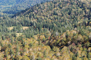
Plants
The park is broadly covered in broad-leafed deciduous forest comprising mainly Quercus crispula Blume and Painted Maple, as well as mixed forests of conifers and broad-leaved trees comprising mainly Ezo Spruce and Erman's birch. Siberian Dwarf Pine can also be seen on mountain peaks and ridgelines at 1,000 m and more above sea level, and flower fields of alpine plants grow everywhere.
A typical vertical distribution of vegetation can be observed on Mt. Yotei, where broad-leafed forest at the foot of the mountain gives way to coniferous forest in the center, and then alpine plants such as Yellow-flowered Rhododendron and Blue Mountain heath blooming at the summit.
Mt. Tarumae is a new volcano, and so there is only forest cover up to around a height of 700 m above sea level. The top of the mountain is covered in communities of alpine plants such as Ledum palustre subsp. Diversipilosum var. nipponicum, Alnus crispa subsp. Maximowiczii, Pennellianthus frutescens, and Arcterica nana, creating a distinctive landscape. A small area of wetlands vegetation has been confirmed to be growing around Lake Okotanpe.
Mixed Forest of Conifers and Broad-Leaved Trees
Wildlife
Amongst the park's wildlife, many animals adapted to forest environments can be observed; mammals species living in the park include the brown bear, Ezo red fox, alpine hare, Hokkaido squirrel, chipmunk, and Ezo deer.
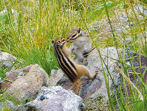
Chipmunk
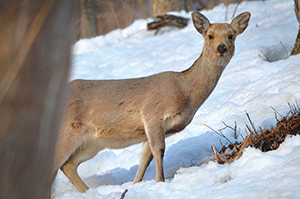
Ezo Deer
Beginning with the black woodpecker --which is designated as a Natural Monument --bird species living in the park include rare species such as the belted kingfisher as well as forest birds such as Japanese scops owl, white-bellied green-pigeon, and coal tit.
Furthermore, water birds such as the spotbill duck and tufted duck can be observed around Lake Shikotsu, but because there are few seaweed beds or small fish for them to eat, both the overall number of birds and number of species are dwindling.
The Ezo deer that were once fed at a sightseeing facility on Nakajima Island in Lake Toya have gone wild and bred, damaging the ecosystem, and so various related organizations are working together to implement countermeasures.
The Ezo deer that were once fed at a sightseeing facility on Nakajima Island in Lake Toya have gone wild and bred, damaging the ecosystem, and so various related organizations are working together to implement countermeasures.
Culture

Toyako Onsen Town
History of Lake Toya Lakeside Development
The area surrounding the park was a living environment for the Ainu People since ancient times. The path to sightseeing activities in this area was opened in 1910, following the eruption of Mt. Usuzan, when the Muroran Main Line and Chitose Line railways linking Hakodate and Sapporo were opened at the end of the Taisho Period (early 1920s). Hotels and golf courses began moving into the area during the early Showa period (late 1920s), and from the mid-1950s to mid-1960s there was a tourism boom accompanying Japan's period of high economic growth, while at the same time the Lake Toya lakeside was developed as a sightseeing destination.
Yamasen Bridge
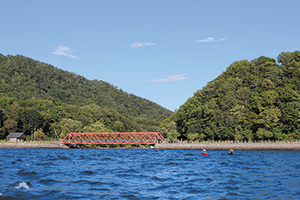
Forests and Mining Development of Lake Shikotsu Lakeside
Before being designated as a national park, the area around Lake Shikotsu had a history of industrial activities, such as mining development. The Tomakomai paper mill built a railway line (Yamasen) in 1908 from Tomakomai to Lake Shikotsu lakeside, constructed a power station on the ChitoseRiver, and logged the forest around Lake Shikotsu. In addition, the Bifue Gold Mine and other mines were developed, some of which still remained in operation after the area was designated as a national park. Today, all of the mines within the park area have been closed down, and the railway bridges and other structures built during that time remain as industrial relics incorporated into the park's landscape.
Page top
Page top
 Hokkaido Regional Environment Office
Ministry of the Environment Government of Japan (JCN1000012110001)
3F, Sapporo Joint Government Building No.1, North 8 West 2 Kita Ward, Sapporo City, Hokkaido Prefecture 060-0808, Japan
Tel: 011-299-1950 Fax: 011-736-1234 E-mail: REO-HOKKAIDO@env.go.jp Location
Copyright Ministry of the Environment Government of Japan. All rights reserved.