Ecotourism in the Western Area
Understand the appeal of wild flora and fauna in World Heritage forests.
The Western Area has a vertical distribution of vegetation extending from the coastal subtropical zone to the cool temperature zone of the mountain area. This vertical distribution is one of the reasons Yakushima Island was registered as a World Natural Heritage site. The Western Area is the only area on the island in which a road runs through the World Heritage site. The road is referred to as the Seibu Rindo (Western Forest Road). Its overhanging trees form a green tunnel, and it is frequently used for bus tours and other activities.
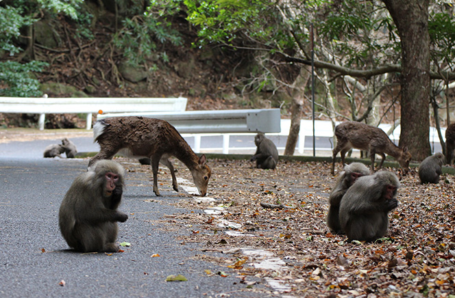
At the low elevations around the forest road, there is secondary growth forest of Japanese chinquapin and evergreen oak previously used for timber fuel. This area also boasts dynamic subtropical vegetation including massive sea fig and Malayan banyan trees supporting Asplenium antiquum, and other plants. As a result of many years of field research, it is possible to observe up-close Yakushima macaques and Yakushima deer live in the wild. It is also possible to find hints of the relationship between nature and humans, and the history of people's lives on the island in the remains of dwellings and charcoal kilns used in various parts of the island until 1965.
There are concerns about the negative impact of a decline in visitor etiquette on the ecosystem, with evidence of people entering the forest on guided trekking tours, and for photography.
In response to this, the Western Area Preservation and Utilization Working Group was established in 2005 as a subordinate organization of the Yakushima Island Region Ecotourism Promotion Council, and ways to protect and use the Western Area were investigated. The Western Area possesses abundant natural resources and is the most appropriate location to directly observe, experience, and study the connections not only between living creatures, but also between nature and people in the wild. It was determined that the use of the area will be limited to activities associated with the preservation of the natural environment, and the impact of use will be continually monitored. The Western Area Preservation and Utilization Rules have been formulated on this basis.
State of use
- Only a limited number of people, fishermen, guided tour members, and researchers conducting ecological research on wild life enter the forest.
- Over eleven years (1996 – 2007), the number of businesses conducting guided tours grew from one to twelve, and six of those conducted walking tours in the forest.
- The areas mainly used for ecotours are the Hanyama and Kawara areas. Particularly in the Hanyama area, there are many attractions such as massive Malayan banyan and sea fig trees , and the remnants of dwellings and charcoal kilns.
Recent efforts
- The Western Area Preservation and Utilization Working Group established by the Yakushima Island Region Ecotourism Promotion Council formulated the Western Area Preservation and Utilization Rules.
Main changes and problems in use
1. Natural Environment
- It appears that some tourists are feeding wild Yakushima deer and macaques, and there are concerns about the impact of this on the ecosystem.
2. Conditions for Visitors
- There are concerns that visitors are taking home items which are important cultural resources from an age when people took sustenance from forest resources, and which can teach us about the history of people living in harmony with nature on the island.