Preparing for Disasters
Eruptions occur about once every 10–20 years at Aso. In these events, magma rises to near the bottom of the crater and then activity continues for a few years.
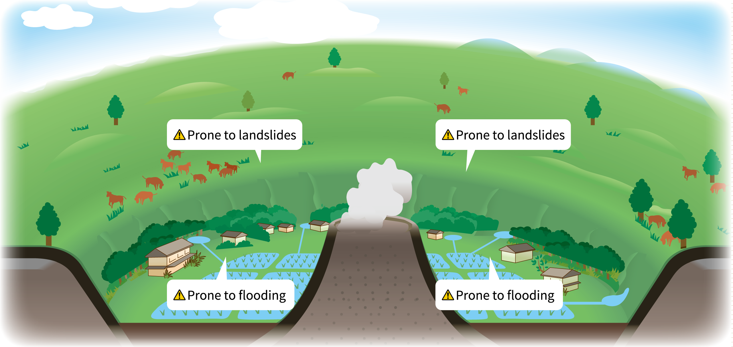
Also, earthquakes attributed to active faults occur frequently, and due to Aso's characteristic topography and high-altitude, cold, rainy weather conditions, there are frequent landslides and floods due to torrential rain.
Tap to enlarge
Volcanic ash from the outer rim and central cone group accumulates on the surrounding land. Torrential rain can cause this land to become fragile and, on occasion, it can suddenly collapse. This collapsed earth and sand then flows into the Shirakawa River in the Nango Valley or the Kurokawa River in Aso Valley, causing flood damage. Furthermore, in the event of a large-scale earthquake, the volcanic ash layer on the ground's surface collapses and leads to landslides.
The topography and geologic strata which form the Aso landscape are a major factor in disasters, and the current landscape can be regarded as the result of repeated disasters in the past.
Learn the topography and geology of your area, and be aware of the hidden risks of disaster.
To Ensure Safe Enjoyment of Aso
Is There a Danger of Sudden Eruption?
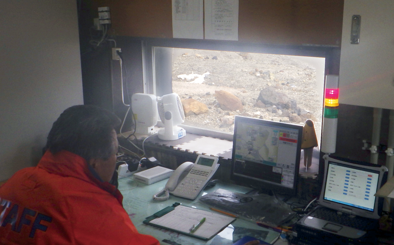
The activity of active volcanoes is constantly monitored by the Japan Meteorological Agency. When volcanic activity increases, the Volcanic Alert Level is raised, and depending on the level, the Aso Volcano Disaster Prevention Council may prohibit entry to the area, or implement measures to prepare for a disaster.
★The current Volcanic Warning Level can be checked on Japan Meteorological Agency website.
Volcanic alert levels at Mt. Aso
| Classification | Abbreviated term | Target area | Levels & Keyword | Expected volcanic activity | Action to be taken by residents/Action to be taken by climbers | Predicted phenomena |
| Emergency warning | Volcanic warning (residential area) |
Residential areas and non-residential areas nearer the crater |
5 (Evacuate) | Eruption or imminent eruption that may cause serious damage in residential areasand non-residential areas nearer the crater. | Evacuate from the danger zone. | ●Lava flows reach or threaten to reach residential areas. |
| 4 (Prepare to evacuate) | Possibility or increasing possibility of eruption that may cause serious damage in residential areas and non-residential areas nearer the crater. | Prepare to evacuate from alert area. Have disabled people evacuate. |
●Lava flows occur and are predicted to reach residential areas in the event eruptions intensify. | |||
| Warning |
Volcanic warning (near the crater) |
Non-residential areas near the crater |
3 (Do not approach the mountain) | Eruption or possibility of eruption that may severely affect places near residential areas (possible threat to life in such areas). |
Stand by and pay attention to changes in volcanic activity. Have disabled people prepare to evacuate in line with current volcanic activity. Refrain from entering the danger zone. |
●Pyroclastic flows occur and reach within a distance of 4 km from the crater, or are predicted to reach this distance as a result of increasing volcanic activity, etc. ●Volcanic cinders disperse and reach within a distance of 2 km from the crater, or are predicted to disperse as a result of small vents being blocked during volcanic activity, etc. |
| 2 (Do not approach the crater) | Eruption or possibility of eruption that may affect areas near the crater (possible threat to life in such areas). |
No action required. Refrain from approaching the crater. |
●A small eruption occurs and volcanic cinders disperse and reach within a distance of 1 km from the crater. ●A small eruption is predicted to occur. |
|||
| Forecast | Forecast | Inside the crater | 1 (Potential for increased activity) | Calm: Possibility of volcanic ash emissions or other related phenomena in the crater (possible threat to life in the crater). | In some cases, it may be necessary to refrain from approaching the crater. | ●Volcanic activity is calm, with the possibility of volcanic ash emissions, etc. in the crater depending on the situation. |
*2 For levels 1 - 3, eruptions are predicted to occur from Mt. Nakadake Crater No. 1 to No. 7 and at Sunasenri-ga-hama.
*3 Volcanic alert levels differ from volcanic gas restrictions.
Be Careful of Volcanic Gases
The crater of Mt. Nakadake emits volcanic gas, including sulfur dioxide, at temperatures of several 100°C. Sulfur dioxide has a strong smell and poses a risk to those with asthma or heart conditions. When the gas increases near the crater, it is dangerous even for people in good health, and thus restrictions on entry are put into effect. The volcano also gives off hydrogen sulfide, which has the smell of rotten eggs, like at Yunotani. This gas is also very dangerous at high concentrations.
★The status of volcanic gas is detected with automatic measuring equipment, and displayed on monitors.
Beware of Lightning
At the summit of Mt. Aso, lightning clouds are that much closer to the ground surface. Therefore, when lightning moves horizontally in dense fog, it increases the risk of a lightning strike. If you are enveloped in dense fog while moving, quickly take refuge in a car, bus, or concrete building, etc.
