National Parks of Japan
Fuji-Hakone-Izu National Park
A Formidable Volcanic Mountain Range Connecting the Islands of the Pacific to the Spectacular Mt. Fuji

The Fuji-Hakone-Izu National Park offers volcanic natural landscapes and an array of diverse scenery forged by human culture. The park is composed of four distinctive areas: the Mt. Fuji Area, the Hakone Area, the Izu Peninsula Area, and the Izu Islands Area.
Overview of Fuji-Hakone-Izu National Park
The Fuji-Hakone-Izu National Park stands as a symbol of the volcanic country that Japan is, featuring Mt. Fuji at its northern end, and a variety of volcanic landforms such as hot springs, ever-changing coastlines, and islands. The park is divided into four areas, including the Mt. Fuji Area, with lakes and plateaus surrounding the iconic peak, and the Hakone Area, once home to a post town on the Tokaido Road that has long prospered as a hot spring spa. Also, the Izu Peninsula Area offers the Amagi Mountain Range, a highly-varied coastline and hot springs, and the Izu Islands Area encompasses the park's many islands, including the volcanically active islands of Oshima and Miyakejima. Spectacular views of Mt. Fuji available throughout the park, as well as its proximity to the Tokyo metropolitan area, have made it the most visited national park in Japan.
The Four Areas of the Park
In the Mt. Fuji Area, visitors can see a typical vertical distribution of vegetation varying with the altitude and the effects of lava. Flows of lava from Mt. Fuji created a rich variety of natural formations at its skirts, including the Fuji Five Lakes, the vast Aokigahara Forest, wind and ice caves, and lava tree molds. Mt. Fuji was registered as a World Cultural Heritage site in 2013 in recognition of its value as a place of worship and a source of art. The Hakone Area has had visitors coming and going since ancient times as a post town on the old Tokaido Road. The area, which boasts superior sceneries and abundant hot springs, including Lake Ashi, the Sengokuhara Wetland, and Owakudani, where fumarole phenomena can be seen and smelt, has welcomed many visitors from overseas in recent years. The Izu landmass became a peninsula when islands and submarine volcanoes of the Southern Ocean moved northward on the Philippine Sea Plate and collided with Honshu. The area was designated a UNESCO Global Geopark in 2018 for its highly-varied coastline, gently- sloping Amagi Mountain Range, and other geological features. The Izu Islands Area is an archipelago stretching southward into the Pacific Ocean for about 120 to 290 kilometers from Tokyo. Each island has its own unique natural scenery, including an array of volcanic landforms made of both old and new lava, beautiful contrasts of different shades of sand and blue sea, and unique flora and fauna nurtured by volcanoes eruptions and the warm Kuroshio Current.
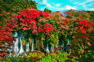
Shiraito Falls
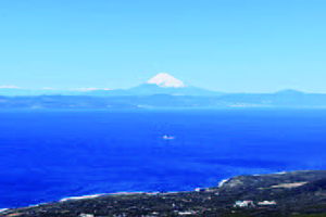
Mr. Fuji from the view point at the top of Mt. Mihara on Oshima Island
Trekking on Rebun-to Island and mountain climbing on Mt. Rishiri are popular ways to explore the area.
Winter adventures
Mt. Rishiri is especially majestic when covered in snow, and draws ski aficionados from around the world looking for the best slope. They look out over the fresh slope in the clear mountain air and gaze at the blue sea as they kick up snow and glide down towards the sea. There is no substitute for the extraordinary experience one can have on Rishiri-to Island.
Because Mt. Rishiri has no lift, visitors need physical strength and skills in backcountry skiing to enjoy winter sports on this mountain. The key to safely enjoy backcountry skiing is to go around March, when the weather stabilizes, and to bring along a knowledgeable and experienced local guide.
Fuji-Hakone-Izu National Park
URL https://www.env.go.jp/en/nature/nps/park/fujihakone/index.html