|
|
 |
| Home >
IEM |
| |
|
|
|
|
|
| |
 |
|
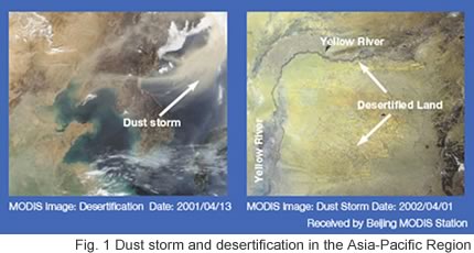
Rapid population growth and economic development
in the Asia-Pacific region has resulted in serious local, national
and regional environmental problems such as floods, droughts,
forest fires, dust storms, air, water and soil pollution, desertification,
salinization, water resource depletion, and soil loss (Fig.1).
Such problems are a serious constraint to sustainable development
in the region. |
|
|
|
 |
IEM Products |
|
The Integrated Environmental Monitoring (IEM)
sub-project will develop an integrated
environmental monitoring system that can be used to detect,
monitor and assess environmental disasters and degradation,
and their impacts in the Asia-Pacific region. The system employs
data primarily from the MODIS (Moderate Resolution Imaging Spectrometer)
sensor on the Earth Observation System (EOS)- Terra/Aqua satellite,
as well as those from ground observations. |
|
 |
|
| |
The main elements of the IEM
system are:
 |
MODIS data: Remote sensing data and images
covering the Asia-Pacific region from a network of satellite
receiving stations in the region is the foundation of
IEM. |
|
Ecological indices: From raw MODIS data
a set of higher order indices and information is derived,
such as a water deficit index, a dust storm index, land
surface temperature, land cover change, and net primary
productivity. |
|
Watershed management model: An integrated
watershed management model is being developed to assess
the state of and changes in ecological goods and services
in such areas as fresh water resources and food production.
With this model strategic policy options for sustainable
watershed management will be explored. |
|
|
|
 |
|
|
|
IEM Achievements in 2002 |
|
|
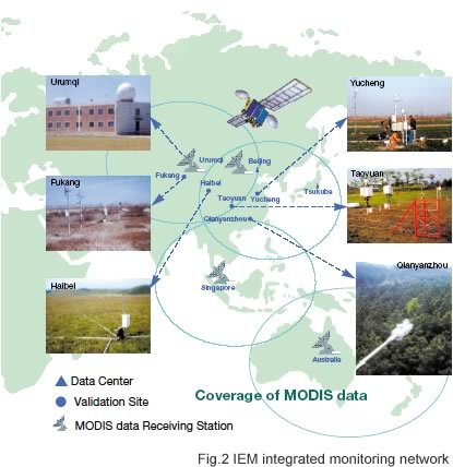
IEM established an integrated monitoring
network system under the auspices of the National Institute
for Environmental Studies (NIES) in Japan and the Institute
for Geographical Sciences and Natural Resources Research
(IGSNRR) of the Chinese Academy of Science in China, and
expanded it with additional participation by the National
University of Singapore and the Commonwealth Scientific
and Industrial Research Organization (CSIRO) in Australia.
The network covers most of the Asia-Pacific region (Fig.2). |
|
 |
|
|
|
IEM also established two data-analyzing
centers at NIES in Japan and IGSNRR in China. These centers
not only store a wide variety of satellite data, but also
various ground-based measurements. A data processing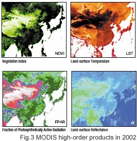 system for deriving the higher order environmental indices
from MODIS data was also completed (Fig.3). These indices
can be used to detect and monitor environmental disasters
/ degradations and identify vulnerable areas. They can
also be used as inputs to a range of models for assessing
climate change, ecological conditions and agricultural
production.
system for deriving the higher order environmental indices
from MODIS data was also completed (Fig.3). These indices
can be used to detect and monitor environmental disasters
/ degradations and identify vulnerable areas. They can
also be used as inputs to a range of models for assessing
climate change, ecological conditions and agricultural
production. |
|
|
|
|
|
|
|
|
Although numerous satellite-derived indices
in the Asia-Pacific region have already been produced
by other projects / organizations, most have yet to be
calibrated or validated by ground-truth data and they
might contain significant uncertainties. Thus, IEM established
five validation sites in a variety of ecosystems in China
such as grassland, dry field, paddy field, forest, and
semi-arid area. The data gathered at these sites includes
information related to radiation, meteorology, and soil
and vegetation. Using these consistent and quality assured
datasets, IEM can produce accurate and reliable information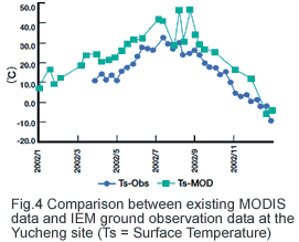
specific to the region. Comparison between existing MODIS
product of surface temperature without ground truth validation
(Ts-MOD) and IEM ground observation data (Ts-Obs) clearly
indicates that the existing product are likely to contain
significant error (Fig.4). |
|
|
|
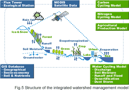
IEM developed an integrated watershed management
model which couples both a MODIS-based ecosystem model
and a sophisticated DSSAT (Decision Support System for
Agro-technology Transfer) model. This integrated model
simulates ecological functions such as the water, heat
and carbon cycles, sediment transport, as well as agricultural
production on a watershed scale (Fig.5). |
|
 |
|
|
|
|
|
|
|
|
This model can be a powerful tool for determining
the wise use of ecological goods and services such as
freshwater resources (irrigation) and crop production.
DSSAT model can provide information on the amount and
timing of irrigation to produce the highest crop yield.
For example, the model has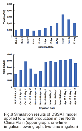 been applied to wheat production in the North China Plain,
one of the largest bases of crop production in China.
With this model, the best timing of irrigation with a
certain amount of water resource between one-time and
two-time irrigation was simulated (Fig.6). According to
the simulation, the highest yield was achieved, by two-time
divided irrigation on April 10 and May 1, which was more
efficient than one-time irrigation. Thus, through scientific
irrigation cheduling, water use efficiency could be improved
while maintaining high wheat yields.
been applied to wheat production in the North China Plain,
one of the largest bases of crop production in China.
With this model, the best timing of irrigation with a
certain amount of water resource between one-time and
two-time irrigation was simulated (Fig.6). According to
the simulation, the highest yield was achieved, by two-time
divided irrigation on April 10 and May 1, which was more
efficient than one-time irrigation. Thus, through scientific
irrigation cheduling, water use efficiency could be improved
while maintaining high wheat yields. |
|
IEM held its first capacity building workshop
in China in September 2002. In addition, it held a workshop
on sustainable environmental management of watershed ecosystems
in the Asia-Pacific region jointly with the MA in Novmeber
2002. |
|
|
|
|
|
|
|
IEM Major Progress in 2003 |
|
|
Participation of China, Singapore, and Australia, the Integrated monitoring
network system covers most of the Asia-Pacific Region |
|
Establishment of five ground-base monitoring sites in China to validate
MODIS data in order to produce accurate and reliable information |
|
Scenarios developed by using integrated watershed management model over
the whole Jialingjian River Catchment contribute to flood-prevention policies
by the Chinese Government
More Details in IEM Technical Summaries 2004 (PDF) |
|
|
|
|
|
|
|
IEM Major Progress in 2004 |
|
|
Participation of China, Singapore, and Australia,
the Integrated monitoring network system covers most of
the Asia-Pacific Region |
|
Continuously monitoring of various ecosystems
to validate MODIS satellite data to produce accurate and
reliable information |
|
Correctly detecting the land cover change,
forest fire, flood area, natural disasters, crop yield
and carbon fixation by using IEM data |
|
Scenarios developed by using integrated
watershed management model over the Changjiang River Catchment
contribute to watershed management policies by the Chinese
Government
More Details in IEM Technical
Summaries 2005 (PDF) |
|
|
|
|
|
|
|
|