
- MOE
- National Parks of Japan
- Minami Alps National Park
- Guide of Highlights
main body
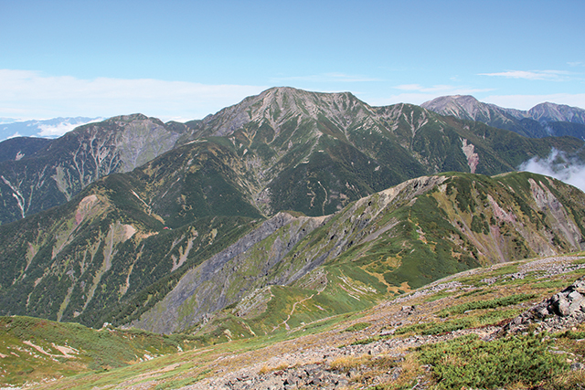
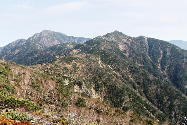
Highlights of Minami Alps National Park
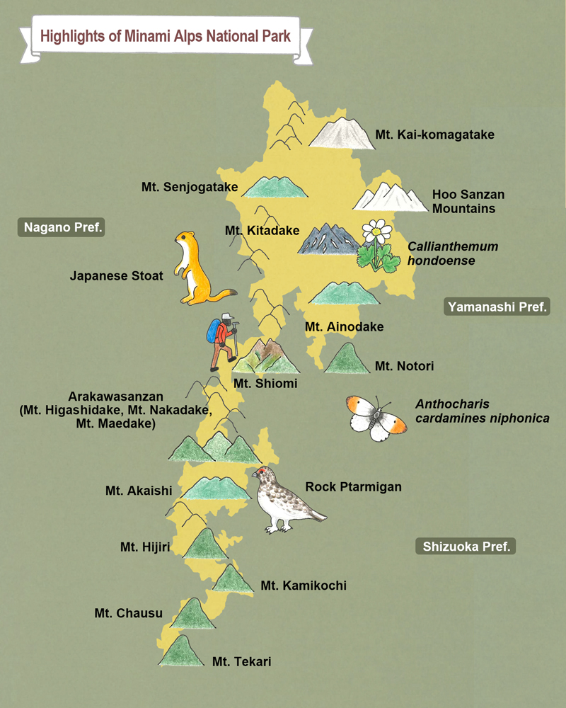 Mt. Kai-komagatake Mt. Senjogatake Hoo Sanzan Mountains Mt. Kitadake Callianthemum hondoense Japanese Stoat Mt. Ainodake Mt. Shiomi Arakawasanzan Mountains [Mt. Higashidake (Mt. Warusawa), Mt. Nakadake, Mt. Maedake] Anthocharis cardamines niphonica Mt. Akaishi Mt. Hijiri Mt. Kamikochi Mt. Chausu Mt. Tekari Mt. Notori
Mt. Kai-komagatake (Mt. Higashi-komagatake)
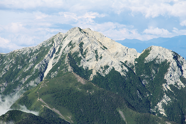
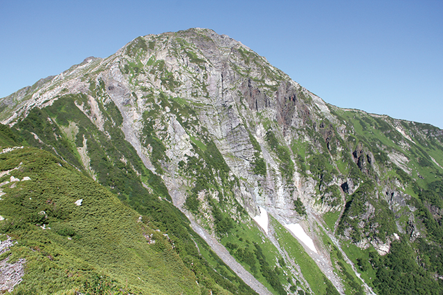
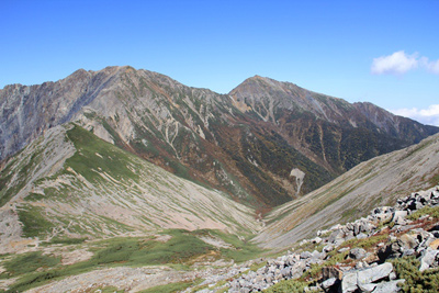
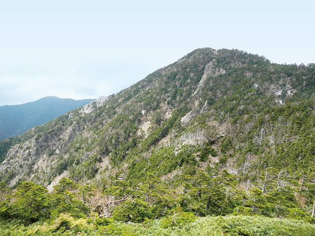
Mt. Kai-komagatake (Mt. Higashi-komagatake)
The entire mountain is covered in granite and its white and elegant appearance is very charming and eye-catching even from a distance. The Kuroto-One route retains many traces of mountain worship in the small shrines. [ 2,967 m above sea level ]
Mt. Senjogatake
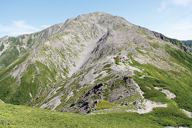
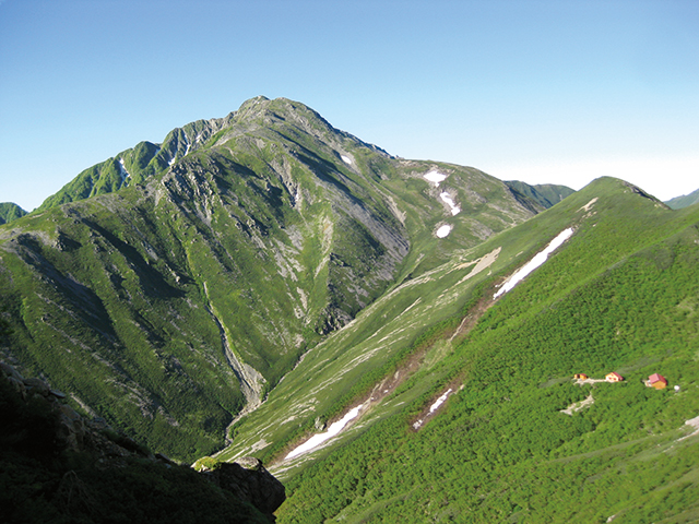
Mt. Senjogatake
Named the Queen of the Minami Alps for the relatively gentle shape and elegant appearance, it is a mountain that is easy to climb with fewer dangerous sites. [ 3,033 m above sea level ]
Hoo Sanzan Mountains (Mt. Jizogatake, Mt. Kannon, Mt. Yakushi)
Hoo Sanzan Mountains (Mt. Jizogatake, Mt. Kannon, Mt. Yakushi)
The mountain mass consists of three peaks: Mt. Jizogatake, Mt. Kannon and Mt. Yakushi. The lines of the mountain ridge are covered with whitish granite sandy soil and gained fame as the mountains of worship and tradition. [ Mt. Jizogatake: 2,764 m above sea level, Mt. Kannon: 2,841 m above sea level, Mt. Yakushi: 2,780 m above sea level ]
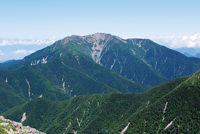
Mt. Kitadake
Mt. Kitadake
As the second tallest mountain in Japan, after Mt. Fuji, it is called Shirane Sanzan (three white summits) together with Mt. Ainodake and Mt. Notori. The Kitadake Buttress is a 600-m tall rock face that extends from the summit on the eastern slope of the mountain. [ 3,193 m above sea level ]
Mt. Ainodake
Mt. Ainodake
Marked by a heavy look and large size, Mt. Ainodake lies on the headwaters of the Oi River, and to its east lays the cirque Kitazawa Kar and Hosozawa Kar, which are glacial landforms, as well as a multiplex mountain ridge formed by the collapse of the mountain. [ 3,190 m above sea level ]
Mt. Notori
Mt. Notori
During the season of lingering snow, the snow left on a mountainside appears as a bird, and those who lived at its foot regarded it as an indicator for the farming calendar, in which the name came about. [ 3,026 m above sea level ]
Mt. Shiomi
Mt. Shiomi
While the mountain has twin peaks, an East and West peak, this unique dome-shaped mountain gives the appearance of an independent peak when viewed from a distance. A host of mountain climbers visit via the Torikura forest road. [ 3,047 m above sea level ]
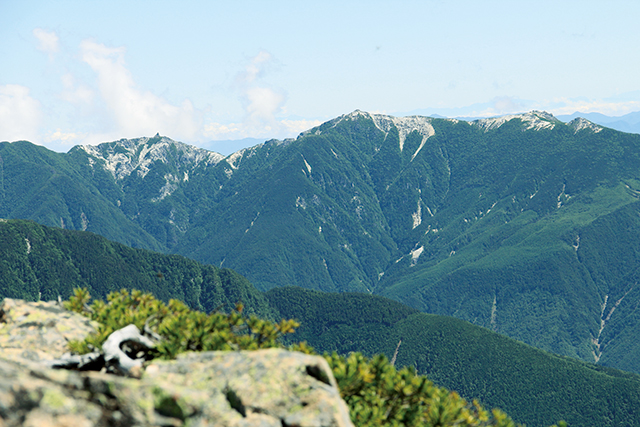
Arakawasanzan Mountains [ Mt. Higashidake (Mt. Warusawa), Mt. Nakadake, Mt. Maedake ]
Arakawasanzan Mountains [ Mt. Higashidake (Mt. Warusawa), Mt. Nakadake, Mt. Maedake ]
Together with Mt. Higashidake (Mt. Warusawa), Mt. Nakadake, and Mt. Maedake, they are known as the Arakawasanzan Mountains. The area is the southernmost point in Japan where clear glacial landforms still exist and is a place to observe a number of cirques alongside alpine meadows. The place along the western edge of Mt. Maedake, called Arakawadaihoukaichi, is a sight to behold dynamic tectonic landforms. [ Mt. Higashidake (Mt. Warusawa) 3,141 m above sea level, Mt. Nakadake 3,084 m above sea level, Mt. Maedake 3,068 m above sea level ]
Mt. Akaishi
Mt. Akaishi
Noted for its massive appearance of ridges jutting out in three directions, Japan's highest triangulation station is located on the summit. The Akashi Mountains were named after this mountain. [ 3,121 m above sea level ]
Mt. Hijiri
Mt. Hijiri
Mt. Hijiri is the southernmost 3,000 m peak in Japan. Visitors can experience its depth from the route that reaches Mt. Akaishi via Mt. Hijiri and Mt. Usagi while gazing upon the panoramic vistas of the Minami Alps. [ 3,013 m above sea level ]
Mt. Kamikochi / Mt. Chausu
Mt. Kamikochi / Mt. Chausu
In between Mt. Chausu and Mt. Kamikochi, there are geographical features called a hexagonal pattern soil (patterned ground), which the ground repeats freezing and melting during the past cold season, resulting in polygonal-lined pebbles of various sizes. [ Mt. Kamikochi 2,803 m above sea level, Mt. Chausu 2,604m above sea level ]
Mt. Tekari
Mt. Tekari
Although the mountain's peak just exceeds the tree line, the entire mountain is covered in forests. Mt. Tekari is the southernmost point at which Siberian Dwarf Pines and rock ptarmigan can be found throughout the world. [ 2,592 m above sea level ]
Wildlife & Plants
Callianthemum hondoense
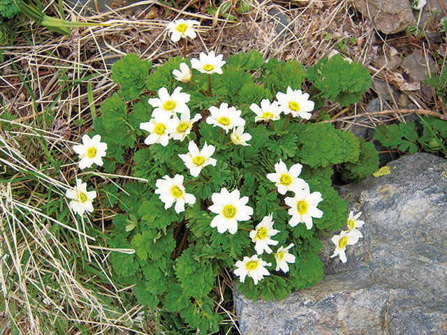
Callianthemum hondoense
It blooms with white flowers with the melting of the snow in late June to early July. It is an endemic species only found in the summit area of Mt. Kitadake in the world.Anthocharis cardamines niphonica
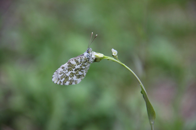
Anthocharis cardamines niphonica
Arriving in Japan when the land was connected to mainland Asia during the Ice Age, this alpine butterfly subsequently moved to higher altitudes when the climate warmed. In Japan, the butterfly now lives only in limited areas in the Mt. Hida, Mt. Akaishi, Mt. Myoko, Mt. Togakushi, and the Mt. Yatsugatake.Japanese Stoat (Mustela ermine nippon)
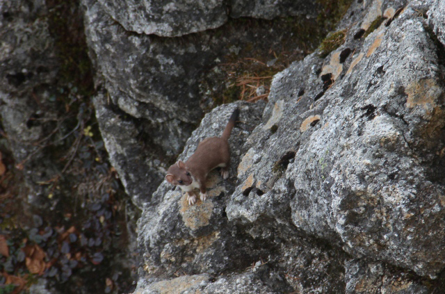
Japanese Stoat (Mustela ermine nippon)
A species of the weasel family, this carnivore inhabits the subalpine zone north of Chubu at an altitude above 1,500 meters.Activities
Mountain Climbing
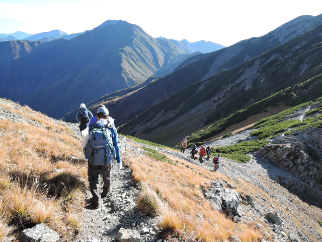
Mountain Climbing
The Minami Alps delight climbers with over 10 peaks in the 3,000 m class, including Mt. Kitadake (3,193 m above sea level), the second highest peak in Japan.Brochures
Map
Page top
Page top
 Kanto Regional Environment Office
Ministry of the Environment Government of Japan (JCN1000012110001)
6F Saitama-shintoshin Joint Government Building No.1
1-1 Shintoshin Chuo Ward, Saitama City, Saitama Prefecture 330-9720, Japan
Tel: 048-600-0516 Fax: 048-600-0517 E-mail: REO-KANTO@env.go.jp Location
Copyright Ministry of the Environment Government of Japan. All rights reserved.