- MOE
- National Parks of Japan
- Daisetsuzan National Park
- Characteristics
main body
Characteristics
The Roof of Central Hokkaido; Known Locally as Kamui Mintara or “the Playground of the Gods”
Date of Designation: December 4, 1934
Area: 226,764 ha
Related Prefecture: Hokkaido
Area: 226,764 ha
Related Prefecture: Hokkaido
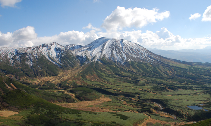
Daisetsuzan National Park is located in the central part of Hokkaido. Sometimes referred to as the roof of Hokkaido, the area designated as a national park includes the Daisetsuzan volcanic group that culminates in Mt. Asahidake (Hokkaido's highest peak at 2,291 m above sea level), other magnificent peaks such as Mt. Tomuraushi, Tokachi Mountain Range and Ishikari Mountain Range, as well as the sources of the Ishikari River and Tokachi River, which are representative landmarks of Hokkaido.
The average elevation of the mountainous regions is approximately 2,000 m. However, their higher latitude gives them an alpine environment that rivals 3000 m class peaks across the rest of Honshu. The vast mountain belt is covered with colorful alpine plants including endemic species such as Oxytropis japonica var. sericea and Lagotis yesoensis. The area is referred to by the Ainu people as Kamui Mintara or the "the playground of the Gods," and its beautiful landscapes are a treat for mountain climbers. Among local treasures are rare animal species such as the Japanese pika and the Parnassius eversmanni daisetsuzzanus, which are said to have survived the ice age, as well as a Miyabe charr that is endemic to Lake Shikaribetsu.
The average elevation of the mountainous regions is approximately 2,000 m. However, their higher latitude gives them an alpine environment that rivals 3000 m class peaks across the rest of Honshu. The vast mountain belt is covered with colorful alpine plants including endemic species such as Oxytropis japonica var. sericea and Lagotis yesoensis. The area is referred to by the Ainu people as Kamui Mintara or the "the playground of the Gods," and its beautiful landscapes are a treat for mountain climbers. Among local treasures are rare animal species such as the Japanese pika and the Parnassius eversmanni daisetsuzzanus, which are said to have survived the ice age, as well as a Miyabe charr that is endemic to Lake Shikaribetsu.
Terrain/ Scenery
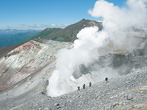
Volcanic Activity
Daisetsuzan National Park consists of the Daisetsuzan volcanic group arranged around the Ohachidaira caldera, the Mt. Tokachi volcanic group named after its highest peak Mt. Tokachi (an active volcano), and the Ishikari Mountain Range, which includes the Mt. Shikaribetsu volcanic group near Lake Shikaribetsu and older geological strata of the Hidaka Mountain Range. Except for the non-volcanic Ishikari Mountain Range, the mountainous areas in the Daisetsuzan National Park were formed through comparatively recent volcanic activity. Active volcanoes include Mt. Asahi (2,291 m above sea level), Mt. Tokachi (2,077 m above sea level), and the Higashi-Taisetsu-Maruyama volcano (1,692 m above sea level). In recent years, Mt. Tokachi in particular has erupted repeatedly.
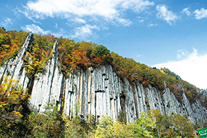
Columnar joints (Tennin Gorge)
The Sounkyo and Tenninkyo gorges are characterized by patterned crevices, giving the impression of a succession of standing polygonal pillars. This landscape was formed through a phenomenon referred to as columnar jointing, which occurs when pyroclastic flow deposits from volcano eruptions slowly cool down, turn into stone, and are subsequently eroded by rivers flows.
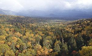
The Sea of Trees in Tokachi-Mitsumata
Calderas are a special feature of active volcanoes. The Ohachidaira caldera owes its current shape to a stratovolcanic explosion some 30,000 years ago. In recent years, it was learned that the Tokachi-Mitsumata basin, which has a circumference of over 10 km and is populated by a mixed forest of needleleaf and broadleaf trees, is a caldera that was formed through a volcanic explosion a million years ago.
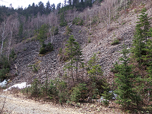
Permafrost
Due to the prevailing cold climatic conditions, the Mt. Daisetsu alpine belt is also subject to certain phenomena typically only observed in artic regions. The Takanegahara Highland consist of layers of peat that have risen to the surface (palsas) amid freezing temperatures, resulting in a structural phenomenon that, depending on size, produces mesh or linear patterns. Moreover, permafrost soil (soil and rocks that for the entire year remain at or below freezing temperatures deep into the ground) is mainly found at 2,000 m above sea level in Mt. Daisetsu, but can also be observed at lower elevations in areas surrounding Tokachi-Mitsumata and Lake Shikaribetsu in the Higashi-Taisetsu area. Even in the summer, a large number of air holes can be seen releasing cold air from the permafrost soil in the ground of the rocky slopes that were formed through an explosion of the Shikaribetsu volcano group in the area surrounding Lake Shikaribetsu. In recognition of its unique characteristics, the area has been certified as the Tokachi Shikaoi Geopark.
In this way, the national park offers an abundance of interesting geography, and visitors can enjoy the healing effects of a large number of hot springs at the foot of the mountain ranges while being surrounded by earth history that has been carved directly into the surrounding landscape.
Plants
While most of the mountains situated within Daisetsuzan National Park are as high as around 2,000 m above sea level, due to the area's high latitudes, the park is noted for its harsh alpine environment comparable to the mountains of the main island reaching as high as 3,000 m, exhibiting a splendid distribution of the alpine belt.
Noted for its vast area, Mt. Daisetsu hosts diverse vegetation, thanks to its geographical features and harsh weather conditions. While the foot of the mountain is a vast forest zone consisting of needleleaf mainly of the Yezo spruce and Todo fir, and broadleaf trees, as the elevation increases, the appearance changes with a coniferous forest and Erman's birch forest, and further, it changes to the forest limit and creeping pine zone. The communities of alpine plants growing near the mountaintop are home to nearly 250 species, which account for 40% of the alpine plants found in Japan.
Noted for its vast area, Mt. Daisetsu hosts diverse vegetation, thanks to its geographical features and harsh weather conditions. While the foot of the mountain is a vast forest zone consisting of needleleaf mainly of the Yezo spruce and Todo fir, and broadleaf trees, as the elevation increases, the appearance changes with a coniferous forest and Erman's birch forest, and further, it changes to the forest limit and creeping pine zone. The communities of alpine plants growing near the mountaintop are home to nearly 250 species, which account for 40% of the alpine plants found in Japan.
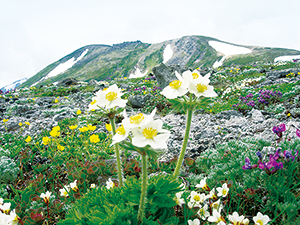
Communities of Alpine Plants
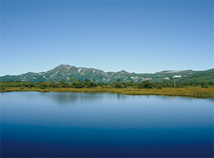
Mt. Tomuraushi Viewed over Numa-no-hara High Moor
At the communities of alpine plants, most of the species are also rare species, such as the Oxytropis japonica var. sericea and Lagotis yesoensis indigenous to Mt. Daisetsu, and the Rishiririndou, whose distribution is limited. The mountaintops retain a number of snowy gorges and snow patches even in the middle of the summer, and the area is filled with colorful alpine flora creating splendid alpine meadows. In addition, a distinctive topography of high moors spreads across the marshland in the plateau region, making a habitat for flora unique to the marshlands and dwarf Japanese spruce.
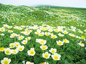
Communities of Geum pentapetalum, etc.
The stunning forest landscape and the appearance of colorful alpine flora indeed creates the landscape called "Kamuimintara" by the Ainu, meaning the Playground of the Gods. In addition, a distinctive topography of high moors spreads across the marshland in the plateau region, making a habitat for flora unique to the marshlands and dwarf Japanese spruce .
Wildlife
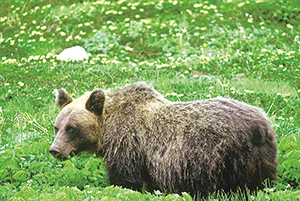
Brown Bear
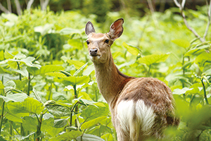
Yezo Sika Deer
Marked by its diverse environmental conditions, Mt. Daisetsu boasts a rich biodiversity that is proportional to the greatness of magnitude. The vast forests of Mt. Daisetsu are abundantly populated by mammals including brown bears, Yezo sika deer, Ezo red fox, Yezo stoat and Hokkaido squirrels , and birds including Blakiston's fish owls ; listed as one of the special natural monuments of Japan, and black woodpeckers, in addition to the rare Eurasian three-toed woodpecker. As for fish, salmonid fish, the Dolly varden , makes its habitat and its subspecies only found in the Lake Shikaribetsu is called the Miyabe charr. The alpine belt is home to the pine grosbeak and spotted nutcracker.
There are a number of wildlife species that can only be found in a limited area in Mt. Daisetsu. Such as Japanese pika ; only found in a cold rocky stretch of Hokkaido, and the Parnassius eversmanni daisetsuzzanus and Freija's Fritillary; the alpine butterfly species that only inhabit in Mt. Daisetsu, these fauna are called relict species that they traveled from a continent during the glacial age and then as a result of warming temperatures, they were left over only in a cold alpine.
There are a number of wildlife species that can only be found in a limited area in Mt. Daisetsu. Such as Japanese pika ; only found in a cold rocky stretch of Hokkaido, and the Parnassius eversmanni daisetsuzzanus and Freija's Fritillary; the alpine butterfly species that only inhabit in Mt. Daisetsu, these fauna are called relict species that they traveled from a continent during the glacial age and then as a result of warming temperatures, they were left over only in a cold alpine.
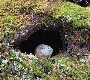
Japanese Pika
Mt. Daisetsu, a habitat for rare flora and fauna, not only has been designated as a special natural monument of Japan in an alpine belt but also the entire stretch, including the headwaters of the Tokachi River, is designated Wilderness Area.
Culture
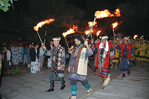
Sounkyo Onsen Fire Festival [Photo:Sounkyo Tourism Association]
Tradition of the Ainu Culture
Every year, when the summer comes around, the Sounkyo Onsen Fire Festival is held in the Sounkyo Onsen. This festival gives visitors some of the exposure to the Ainu's traditional ceremony called the fukuro owl ritual, a folk dance that the Ainu dance along to traditional tunes and other aspects of the Ainu culture that was descended and handed down by the people of Ainu who are the indigenous inhabitants of Hokkaido through centuries. Other highlights of this festival are the fire taiko drums that echo throughout the gorge and fireworks display.
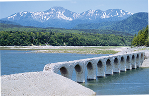
Taushubetsu River Bridge
Inheritances from the Pioneer Days
In parallel with National Route 273 extending north to south from the town area in Kamishihoro to the Nukabira Gensenkyo through the hilly forest region in Tokachi-Mitsumata, there are a number of concrete arch bridges from the former National Railway Shihoro Line that went defunct in 1987. These elevated railway bridges are remnants that pass down the pioneering history of Higashi-Taisetsu as the Heritage of Industrial Modernization. Above all, the Taushubetsu River Bridge spanning the Taushubetsu River sinks to the lake bed from around June to October in times of rising water from the Lake Nukabira, which is a dam lake. It is called a fairy lake as the water lowers from around January revealing the bridge from the frozen surface of the lake. These bridges became the designated Hokkaido Heritages in October 2001 as "The Former National Railroad and Concrete Arch Bridge on the Shihoro Line."
